
| Area | Elk River |
| Topic | Roads: Densities in Elk River Sub-Basins 2000 |
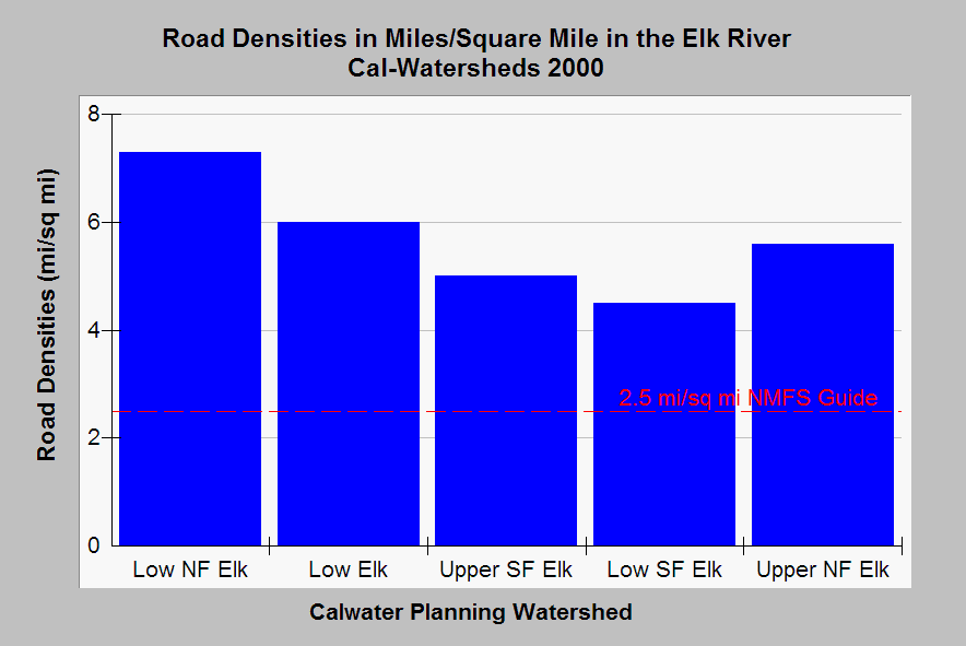
| Caption: This chart shows the road density within all Elk River Calwater Planning Watersheds as miles of road per square mile of watershed. Although Lower Elk River (Low Elk) has some suburban development, most roads in the Elk River watershed are related to timber harvest. Roads on timberlands may not reflect skid trails, temporary roads or tractor trails and so should be viewed as conservative. Proper watershed function for salmonid habitat according to National Marine Fisheries Service (1996) is 2.5 miles per square mile, which is shown as a reference above. Data from Legacy the Landscape Connection with summary statistics generated by the Institute for Fisheries Resources. See Info Links for access to more background information. | |
 |
To learn more about this topic click Info Links .
To view additional information (data source, aquisition date etc.) about this page, click Metadata .
To view the table with the chart's data, click Chart Table web page.
To download the table with the chart's data, click er_roads_xings_2000.dbf (size 2,871 bytes)
To download the table with the chart's data as an Excel spreadsheet, click er_roads_xings_2000.dbf.xls (size 4,096 bytes) .
| www.krisweb.com |