 |
Bibliography | Home | |
| The average precipitation in the Trinity Basin is 35-75 inches per year. With mountain peaks over 8,000 feet and lower ridges surrounding the river at 4000-5000 feet, much of the moisture comes in the form of snow. Records for the Trinity River at Lewiston show that before dam construction high flows were commonplace during the months of April through June, as snow melted (McBain and Trush, 1997). These regular pulses of high water cleaned the river bottom of silt and delivered new spawning gravel for salmon. Reduced flow after 1964 allowed the riparian vegetation to encroach on the river and made the active channel narrower and disconnected it from the former flood plain. |
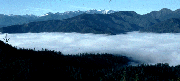 The Trinity River watershed is mainly mountains, which are often covered with snow. During winter a blanket of fog often forms over the river valley. |
| The flow regime of the Trinity River changed dramatically after the Trinity and Lewiston Dams were constructed in 1963. Winter and spring floods no longer occurred because water was trapped in Trinity Reservoir. In the early days after dam construction, 90% of the water from the basin was transferred to the Central Valley. The Secretary of the Interior re-allocated basin water so that approximately 25% is allowed to flow down the Trinity River in 1992. The Record of Decision in December 2000 on Trinity River flows will increase the amount of water to be retained in the basin to 50% of annual flows. |
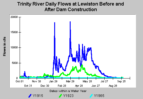 This graph shows the dramatic change in Trinity River flows before and after dam construction. The 1915 water year shows a typical pre-dam wet year with several substantial peaks in flow, including high flows into June. A pre-dam dry year (1923) shows small winter peaks but with substantial spring flow. Post-dam Trinity River flows (1965) are very low and uniform. |
| Before dam construction, high winter and spring flows rejuvenated the river each year. The river would flush out fine sediment, move large amounts of gravel and cobble downstream, and remake itself regularly. Now the dam prevents flushing flows and new gravel is no longer moved downstream. Instead, the river has accumulated large amounts of fine sediment, which erodes from the surrounding land. This sediment plugs the remaining spawning gravel. |
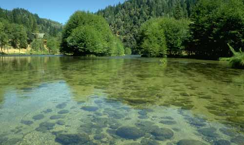 The bed of the Trinity River below Grass Valley Creek is filled with fine sediment because the river's normal flushing flows have been cut off by the dam. Encroaching riparian vegetation narrowly confines the channel at the center of the photo. |
![]()
References
McBain and Trush. 1997. Trinity River Flow Maintenance Study. Performed under contract to the Hoopa Tribe. Contract #30255 by McBain and Trush. Arcata, CA. 481 pp. [11.9Mb]
| www.krisweb.com |