 |
 |
| Background | Hypotheses | Bibliography | Maps | Home |
| |
|
| Background | Hypotheses | Bibliography | Maps | Home |
KRIS Web Background Pages: Sediment
![]()
There are five main sources of sediment data in KRIS Big River: Mendocino Redwood Company (MRC), Hawthorne Timber Company (HTC), the USFS Redwood Sciences, North Coast Regional Water Quality Control Board (NCRWQCB) and Matthews and Associates (2001)..
References on charts in KRIS Big River are based in part on targets put forth in the Big River TMDL (2001). The Garcia River (US EPA, 1998) and Ten Mile River (US EPA, 2000) also have similar standards. The sediment levels defined appear reasonable given existing information both locally and regionally. For example, the 14% threshold for fines (<0.85 mm) is conservative relative to the National Marine Fisheries Service (1996) guidelines for properly functioning salmon habitat, which set a limit of 12% fine sediment less than 0.85 mm. McHenry et al. (1994) found that fines less than 0.85 mm were nearly 100% lethal to coho and steelhead eggs when they exceeded 13% within the redd. Fine-gravel sized particles <6.4mm may intrude into the stream bed, forming a layer in the stream gravels which may inhibit the emergence of fry (Chapman 1988). A numeric target of 30% for fines <6.4mm was proposed by the EPA for the Big River. Barnard (1992) used freeze core sampling in Freshwater Creek, a Humboldt Bay tributary, and found that sediment less than 1 mm comprised less than 10% of the samples at most sites (see notes on baseline conditions for fines).
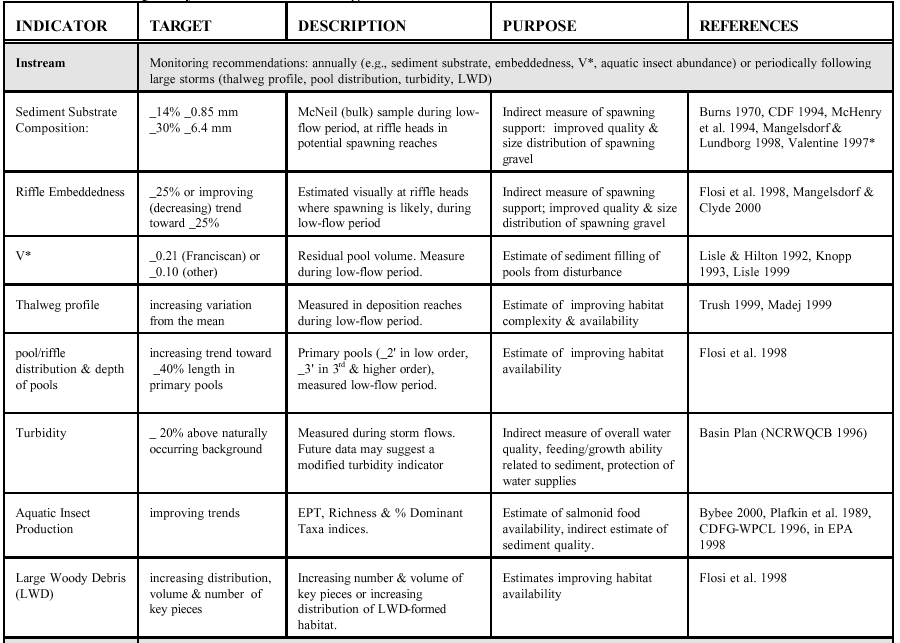 |
At left is Table 4, Water Quality Indicators and Targets, from the Draft Big River, Total Maximum Daily Load for Sediment (EPA, 2001). KRIS Big River uses these target values as thresholds on charts to indicate whether values at a particular location indicate impairment. |
MRC has five sediment monitoring segments in the Big River basin: the East Branch of the North Fork, the Mainstem, the South Fork, Daugherty Creek, and Ramon Creek (map). Each stream segment has McNeil bulk samples and permeability measures taken from at least four riffle crests or "tailouts." Each site also has three cross-sectional surveys and a thalweg longitudinal profile survey. Stream segments used for monitoring are 20-30 bank-full channel widths in length. KRIS Big River contains MRC permeability and bulk gravel samples and compares these results to the Big River TMDL thresholds.
Matthews and Assoc. (2001) and MRC both use dry sieve sampling methods, but these are not directly comparable to wet sieve samples which comprise the bulk of previous studies and the foundation for TMDL (EPA, 2001) discussions. KRIS Big River uses conversion factors from Shirazi and Seim (1979) to estimate decreases in fines sediment of different size classes. The smaller fraction (<1.0 mm) has a greater amount of water weight than larger size classes (i.e. 6.4 mm). Although the U.S. EPA and California State Water Resources Control Board do not necessarily endorse this method of conversion, it seems conservative in light of other literature such as McHenry et al. (1994).
MRC Permeability: The MRC permeability data shows variability within each study segment. Each of the five segments studied had four to ten tailouts with between two and eight grid locations in each tailout. A grid location consisted of an evenly spaced 12-point grid with four to ten separate, randomly selected measurement points. This sampling design led to 637 permeability measurements from 125 grid locations in 34 tail-outs in the year 2000. Individual measurements from each grid location were averaged, but also used as independent data points in this analysis. The summary statistics presented in KRIS were derived from averaging the individual measurements from each grid point, then averaging the data collected from each grid, then averaging each tail-out, and finally averaging all the tail-outs to represent the permeability for a stream segment. The natural log of permeability derived by Tagart (1976) and McCuddin (1977) (as cited in McBain and Trush, 2000) equates the permeability data to fry survival (Survival = -0.82530 + 0.14882 * natural log of permeability). The survival relationship is an index of spawning gravel quality and is currently one of the few approaches that quantitatively links a biological relationship to permeability data. However, this calculated index for survival has had very limited testing.
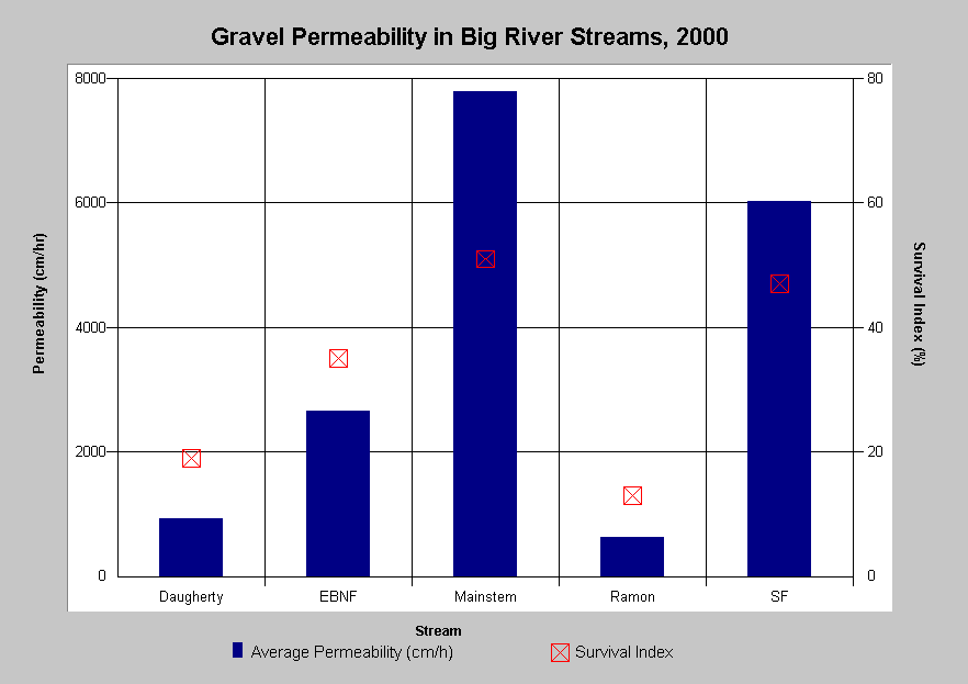 |
Mendocino Redwood Company measured gravel permeability in five Big River stream segments in 2000. High permeability values represent favorable conditions for incubating eggs and alevins. Predicted values for percent egg-to-fry survival are displayed by the red markers. The South Fork and Mainstem Big River had moderately low permeabilities, leading to predicted values for percent egg-to-fry survival in the 50% range. Ramon Creek, Daugherty Creek and the East Branch North Fork Big River had low permeabilities and low estimated values for percent egg-to-fry survival, with the former two having survival of less than 20%. There was large sampling variability within each stream segment. |
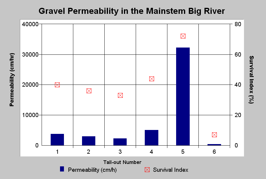 |
Mean gravel permeability in the Mainstem Big River ranged from 400 to 5,000 cm/hr with the exception of one pool tail-out location, T5, where the mean gravel permeability measured 32,000 cm/hr. The T5 site may be indicative of the potential for the reach to regain suitable habitat values. The red markers indicate predicted values for percent egg-to-fry survival, which ranges from less than 10% to nearly 80%. The problem with mainstem locations and spawning survival may have more to do with bedload mobility than with permeability. |
MRC Dry Sieve McNeil Samples: The MRC Big River sampling locations rarely exceeded the TMDL threshold for sand-sized sediment (<0.85 mm), but were at or near the threshold for the TMDL threshold for sand and fine-gravel-sized sediment (<6.4 mm). This was despite the fact that MRC measured fines less than 5.6 mm instead of the standard 6.4 mm, which would bias samples low. While TMDL thresholds are based on a volumetric (wet sieve) method, MRC uses a gravimetric (dry sieve) method. Very fine particles are generally silt and clay, which have a much greater capacity to hold moisture. Drying the sample substantially lowers the results for fines less than 0.85mm but makes less difference in the sand and fine gravel size class (<6.4 mm).
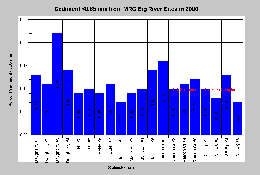 |
The chart at left shows Big River McNeil dry sieve results for percent fines less than 0.85 mm from 2000 for all Mendocino Redwood Company sites. Fine sediment only exceeded the adjusted TMDL size class reference at Daugherty Creek and Ramon Creek, although samples are biased low because of the dry sieve technique. Data provided by MRC. |
|
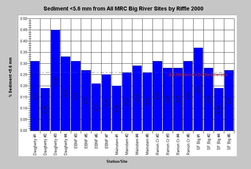
This chart summarizes McNeil dry sieve results for percent fines less than 5.6mm for all Mendocino Redwood Company sites. Measurements exceeded the adjusted TMDL reference for fines less than 6.4mm at 35% of the sampled tailouts. Daugherty Creek had the highest values with three of four sampling stations exceeding 26% by weight. The 6.4mm class size was not reported by MRC for this location, so the 5.6mm class is displayed instead. Data provided by MRC. |
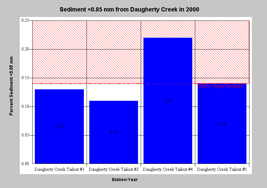 |
Daugherty Creek McNeil dry sieve results for percent fines less than 0.85mm in the year 2000 are shown at left. Notice the pattern of values relative to the reference, and then compare to the pattern in the chart below. While the values for fines 0.85 mm fall below the TMDL threshold, those for the large size class (<6.4 mm) do not. Data provided by MRC. |
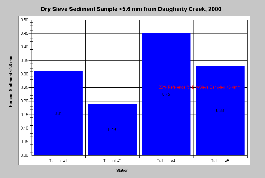 |
Fines less than 5.6 mm from the 2000 from MRC Daugherty Creek stations are at left. Values exceed the TMDL threshold at three of four locations despite the fact that MRC is reporting 5.6 mm not the 6.4 mm size class that the TMDL reference reflects. This means the sample is biased low. Data provided by MRC. |
Hawthorne Timber Company McNeil Samples (Wet Sieve): HTC has two sediment monitoring stations in the Big River basin: Lower Two Log Creek and Lower Little North Fork Big River (map). They measured fine sediment less than 0.85 mm and less than 4.0 mm using the wet sieve technique.
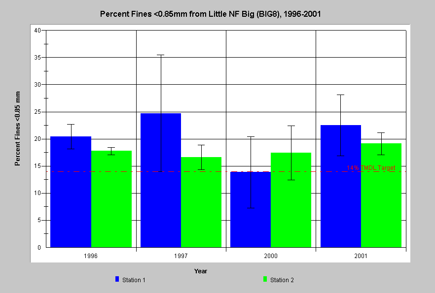 |
Individual McNeil wet sieve results for percent fines less than 0.85mm from the HTC Lower Little North Fork Big River site (BIG8) in 1996 are shown at left. The bars represent the average of four McNeil samples at each station and the whiskers are one standard deviation from the mean. The range median values at all but one location are above the TMDL less than 0.85 mm reference of 14%. Consequently, this site is likely limited with respect to spawning habitat suitability. Data supplied by the Hawthorne Timber Company. |
North Coast Regional Water Quality Control Board V* Data: The NCRWQCB commissioned a study of physical habitat variables in 60 streams in northwestern California (Knopp 1993), including streams in the KRIS Big River project area (Caspar Creek, Hare Creek, Bunker Gulch, Berry Gulch and Russian Gulch). See map. Knopp (1993) found significant linkage between sediment in pools, particle size distribution and watershed disturbance. The primary index used in KRIS Big River is V*, a measure of the proportion of a pool filled with fine sediment. The proportion of fine sediment in pools correlates with annual sediment yield and changes in V* correspond to changes in the balance between sediment inputs and flow (Lisle and Hilton 1993). V* is user friendly in that it is relatively inexpensive and easy to implement. The Draft Big River TMDL proposed a V* target threshold of 0.21.
 |
V* values from eight stream reaches in the Big River area are displayed at left. The Draft Big River TMDL proposed a V* target of 0.21, shown for reference, is exceeded at all sites. South Fork and North Fork Caspar Creek come closest to the target, with Russian Gulch and Hare Creek also not far above the threshold. Data from Knopp (1993). |
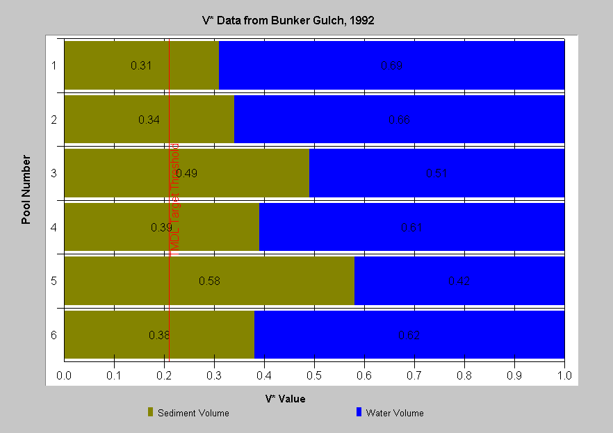 |
The chart at left shows actual V* measurements by pool in Bunker Gulch, a tributary to Hare Creek in 1992. The weighted average of the stations yielded a V* of 0.41 (41%) in 1992, illustrating an elevated sediment load which is almost twice the Big River TMDL V* target threshold. Individual values ranged from 0.31 to 0.58. Data from Knopp (1993). |
Redwood Sciences Lab Caspar Creek Sediment Studies: Another source of V* data in KRIS Big River is the US Forest Service, Redwood Sciences Lab studies in Caspar Creek. Pool sediment loads, bed form and cross-section studies, longitudinal profiles and woody debris mapping have been on-going for at least a decade, while other, measurements, such as suspended sediment and turbidity, have been collected since 1963.
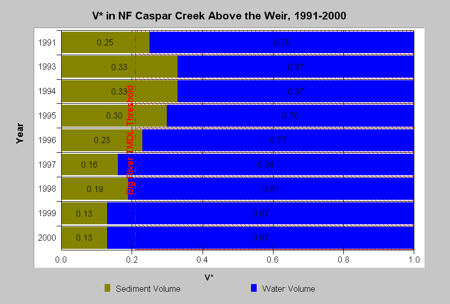 |
Annual average V* values from NF Caspar Creek above the weir are displayed at left. There has been a declining trend of sediment since a peak in 1993-1995 and the North Fork has been below the TMDL V* threshold value since 1997. Logging took place in the North Fork from 1986 to 1990. High sediment from 1991 through 1995 is likely linked to logging disturbance and subsequent declines indicate recovery. Data collected by Redwood Sciences Lab, USFS. |
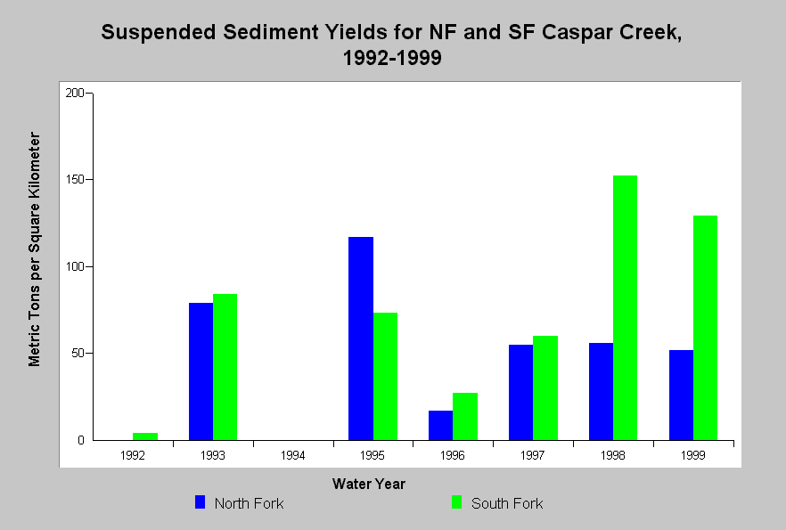 |
Annual suspended sediment (in metric tons per square kilometer) passing over the North and South Fork weirs during the same period as the V* data above are displayed at left. Suspended sediment in the North Fork Caspar peaked in 1993 and 1995 and then started to decrease.. This is likely related in to high flows in those years and also to the preceding watershed disturbance and subsequent recovery. |
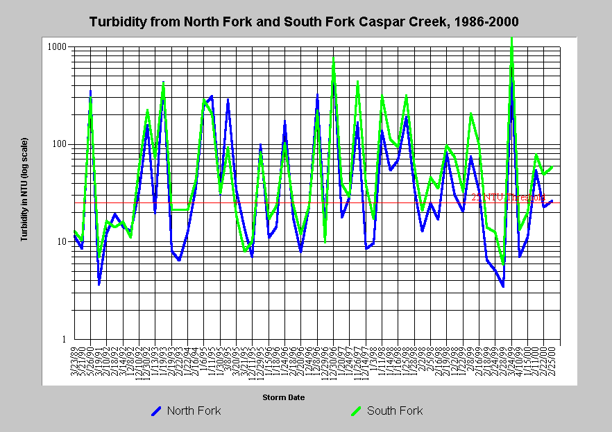 |
Turbidity, displayed at left in Nephlometric Turbidity Units (NTU), varies markedly among years between the North and South Forks of Caspar Creek. Turbidity has a strong relationship with precipitation and runoff but watershed disturbance will also cause an increase. The 25 NTU threshold on the chart is taken from Sigler, which indicates that steelhead juveniles exhibit reduced growth when water clarity drops below this level. March 1999 storm produced the greatest turbidity in the 15 years of automated turbidity record. |
Matthews and Associates (2001) Sediment Budget Related Data
Graham
Matthews & Associates(2001) prepared a sediment source analysis and
preliminary sediment budget for the
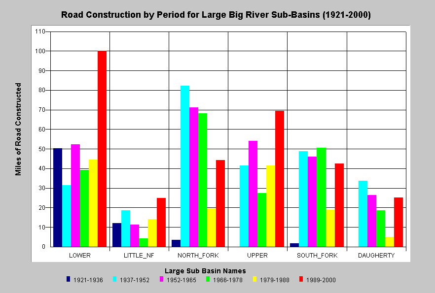 |
The chart at left shows road construction by period for large Big River sub-basins as calculated from aerial photos and CDF data. Matthews (2001) reported improvements in management practices since 1974 have resulted in decreases in road-related mass wasting and harvest-related surface erosion, although sediment delivery from these processes are still well above estimated background rates. Significant construction of new roads has led to increasing sediment yields from road surface erosion, despite improved practices. |
Habitat typing data can also be used to analyze sediment impacts on habitat. For example, high sediment yield reduces pool frequency and depth and increases embeddedness. See Fish Habitat Information in KRIS Big River page for further discussions.
![]()
References
Barnard, 1992. Physical and Chemical Conditions in Coho Salmon (Oncorhynchus kisutch) Spawning Habitat in Freshwater Creek, Northern California. Masters Thesis. Humboldt State University, Arcata, CA. 81 p. plus appendices.
Hilton, S. and T.E Lisle. 1993. Measuring the Fraction of Pool Volume Filled with Fine Sediment. Res. Note PSW-RN-414. US Forest Service, Pacific Southwest Research Station. Albany, CA . 11 pp.
Knopp, C. 1993. Testing Indices of Cold Water Fish Habitat. North Coast Regional water Quality Control Board, Santa Rosa, CA. Cooperatively sponsored by the USDA Forest Service.
Matthews and Associates.2001. Preliminary Sediment Budget Analysis for the Big River. Performed under contract for Tetra Tech and the U.S. EPA. Graham Matthews and Associates, Weaverville, CA. 74 pp.
McBain and Trush. 2000. Spawning gravel composition and permeability within the Garcia River watershed, CA. Final Report. Prepared for Mendocino County Resource Conservation District. 32 pp. without appendices.
McHenry, M.L., D.C. Morrill, and E. Currence. 1994 . Spawning Gravel Quality, Watershed Characteristics and Early Life History Survival of Coho Salmon and Steelhead in Five North Olympic Peninsula Watersheds. Port Angeles, WA. 59 pp. without appendices.
National Marine Fisheries Service. 1996. (Table 1 from...) Coastal Salmon Conservation: Working Guidance for Comprehensive Salmon Restoration Initiatives on the Pacific Coast. US Dept. Commer, NOAA. 4 pp.
Reid, L. 1981. Sediment Production from Gravel Surfaced Forest Roads with Stream Networks in Two Basins, Western Cascades, Oregon. Oregon State University. M.S. Thesis, Corvallis, OR.
Sigler, J.W., T.C. Bjornn, and F.H. Everest. 1984. Effects of Chronic Turbidity on Density and Growth of Steelheads and Coho Salmon. Transactions of the American Fisheries Society. 113:142-150.
Shirazi, M. A., and W. K. Seim. 1979. A stream system evaluation - an emphasis on spawning habitat for salmonids. U. S. Environ. Prot. Agency, EPA -600/ 3- 79- 109, 36 p. Corvallis Res. Lab. Corvallis, Oregon.
US Environmental Protection Agency (USEPA). 1998. (Final) Garcia River Sediment Total Maximum Daily Load. Dated 16 March 1998. USEPA, Region IX. San Francisco, CA. 51 pp.
U.S. Environmental Protection Agency. 2000. Ten Mile River, Total Maximum Daily Load for Sediment. Region IX. San Francisco, CA. 89 pp. Summary and Responses. 18 pp.
U.S. Environmental Protection Agency. 2001. Big River, Total Maximum Daily Load for Sediment. Region IX. San Francisco, CA. Figure 1 (Map). Summary and Responses. 18 pp.
![]()
| www.krisweb.com |