

|
|
|
| Background | Hypotheses | Bibliography | Maps | Home |
Timber Harvest Information in KRIS Big River
KRIS Web Background Pages: Vegetation Types
![]()
The 1994 Landsat imagery, processed by the U.S. Forest Service Southwest Region Remote Sensing Lab, is available in the KRIS Big River Map project. Landsat imagery for most other areas of the State is also available (Warbington et al., 1998; Schwind, 1999). These data allow a quick review of seral stages in various Calwater planning units. The USFS classification system, which uses ten size classes, but not tree type, was chosen. Tree size was then used as a surrogate for seral stage. Timber harvest data from the California Department of Forestry CDF is also incorporated into KRIS Big River Maps. These can be used in conjunction with the USFS vegetation classification to explore watershed disturbance.
Watersheds with lower disturbance levels are more likely to have a diverse assemblage of salmonid species (Reeves et al., 1993). Reeves et al. (1993) found that in Oregon coastal watersheds where timber harvest exceeded 25%, streams had lost salmonid species diversity and tended to be dominated by one salmonid species. The Non-Forest, Sapling (1-4.9") and Small Tree (5-12") components often represent logging. If these components comprise more than 30% of the vegetation and timber types, then cumulative effects risks in a watershed should be considered during watershed assessment.
The Fire and Resource Assessment
Program (FRAP) of CDF has recently completed a project that shows the changes
in the landscape between 1994 and 1998, based on Landsat data (Fisher,
2001). This process, called change scene detection, is very useful in KRIS Map
projects because it helps update vegetation coverages that were based on 1994
imagery.
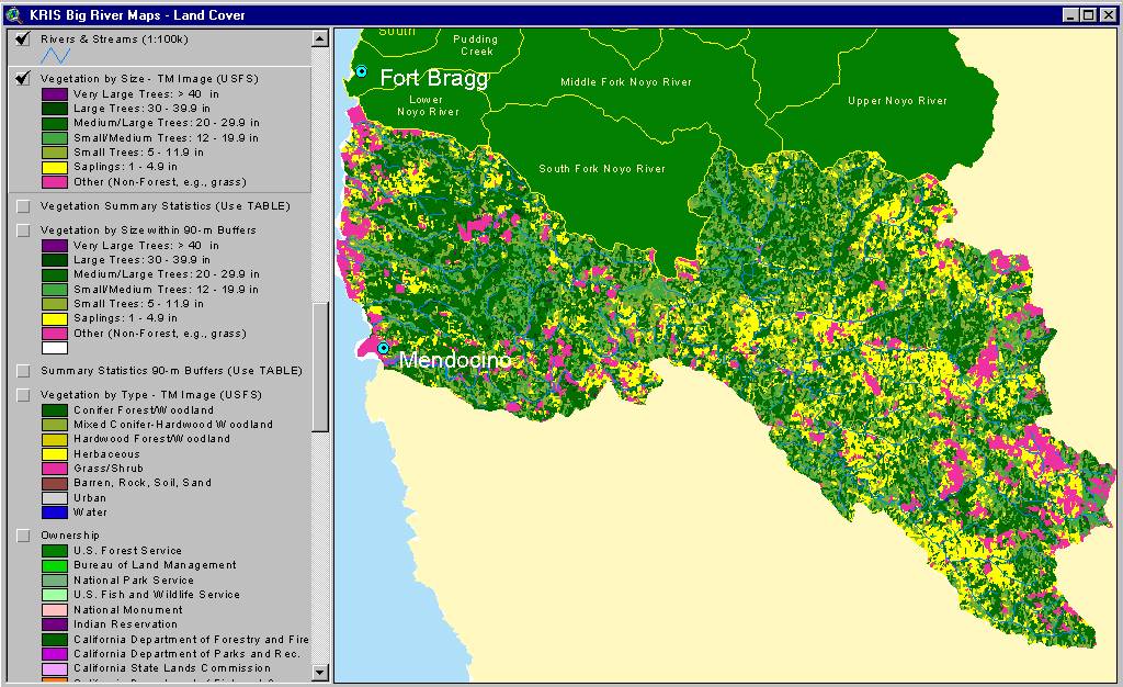 |
This image, from the KRIS Big River Map project, shows USFS vegetation coverage derived from 1994 Landsat imagery for the entire Big River Basin. Large Non-Forest components in the east and west are natural due to grasslands on interior Central Belt mélange terrain and on the marine terraces along the coast. The northern part of the watershed, mostly in Jackson Demonstration State Forest, has substantial components of Small-Medium (12-19.9") and Medium/Large trees (20-29.9") interspersed with small patches of Large Trees (30-39.9"). This indicates a more mature forest than in the South Fork, Lower Big River, Daugherty Creek and the upper North Fork, which are industrial timber lands.(81 KB) |
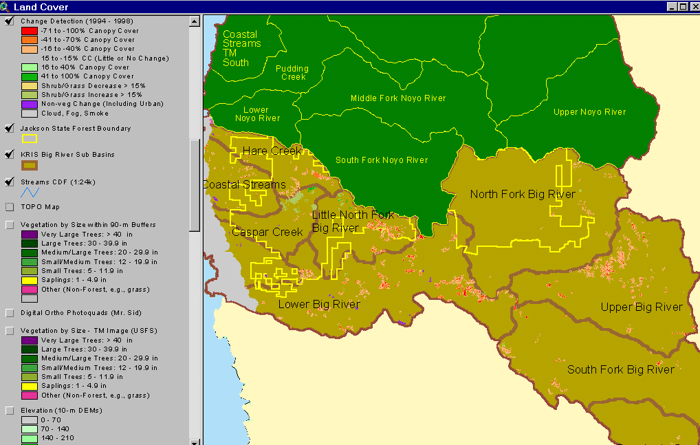 |
The image at left shows Big River KRIS subbasins and change scene detection between 1994 and 1998 Landsat images provided by the California Department of Forestry, Fire and Resource Assessment Program, Sacramento. The Big River basin showed the greatest vegetation reduction (orange and reds) in the Lower and Upper Big River basins. The North Fork Caspar Creek showed canopy increase (green/light green) as forests grew. Loss of canopy in the Coastal Tributary basin is driven by residential development, as opposed to forestry. (55 KB) |
 |
This bar chart from the KRIS Big River database shows vegetation and timber types in the Chamberlain Creek Calwater planning watershed, in the North Fork Big River basin. The information was derived from a 1994 Landsat image by the U.S. Forest Service. This area had a large component of medium-large trees (20"-29.9") as of 1994, which comprised 51% of the watershed. Large trees (30-40") comprised 2% of the watershed while small to medium-sized trees (12-19.9" diameter) made up 20% of the watershed. Small trees (5-11.9" diameter) made up 22% of the watershed and saplings (1-4.9" diameter) only 5%. There was no Non-Forest component. (15 KB) |
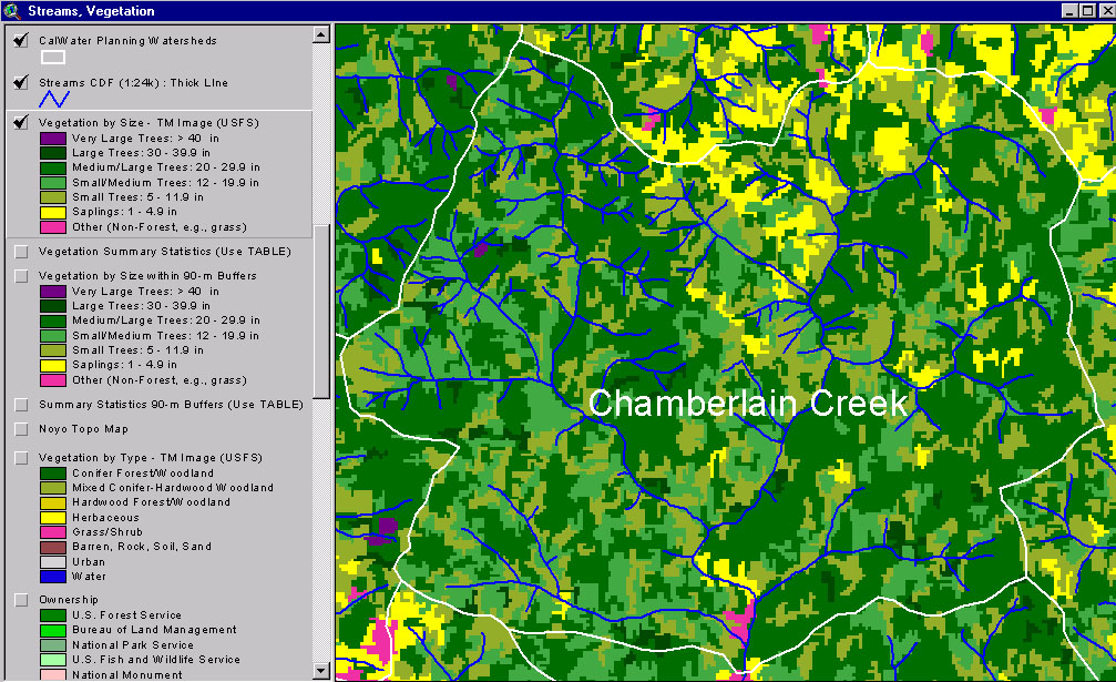 |
This image, from the KRIS Big River Map, project shows USFS vegetation and stand types for the Chamberlain Creek (NF Big River) Calwater planning watershed, derived from a 1994 Landsat. (361 KB) |
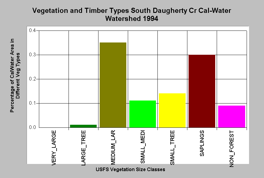 |
The bar chart at left shows vegetation and timber types of the South Daugherty Creek Calwater planning watershed, which is the same as the Daugherty Creek watershed proper. The area had a large component, 35%, of medium-large trees (20"-29.9") as of 1994, and medium sized trees (12-19.9" diameter) made up 11% of the watershed. The large combined components of small trees, 14% (5-11.9" diameter), 30% saplings (1-4.9" diameter) and 9% non-forest, indicate a rapid rate of recent timber harvest. With a disturbance covering 50% of the watershed in less than a 15 year period, cumulative watershed effects risk are likely to be elevated. (16 KB) |
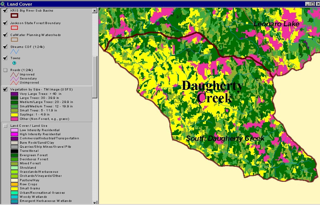 |
This image, from the KRIS Big River Map project, shows USFS vegetation and stand types for the Daugherty Creek watershed, derived from a 1994 Landsat. Non-Forest and Saplings in this basin are mostly associated with recent timber harvest. The scale of accuracy for stands is one hectare. An exception is in the eastern part of the watershed, where Central Belt Franciscan bed rock gives rise to natural grasslands.(66 KB) |
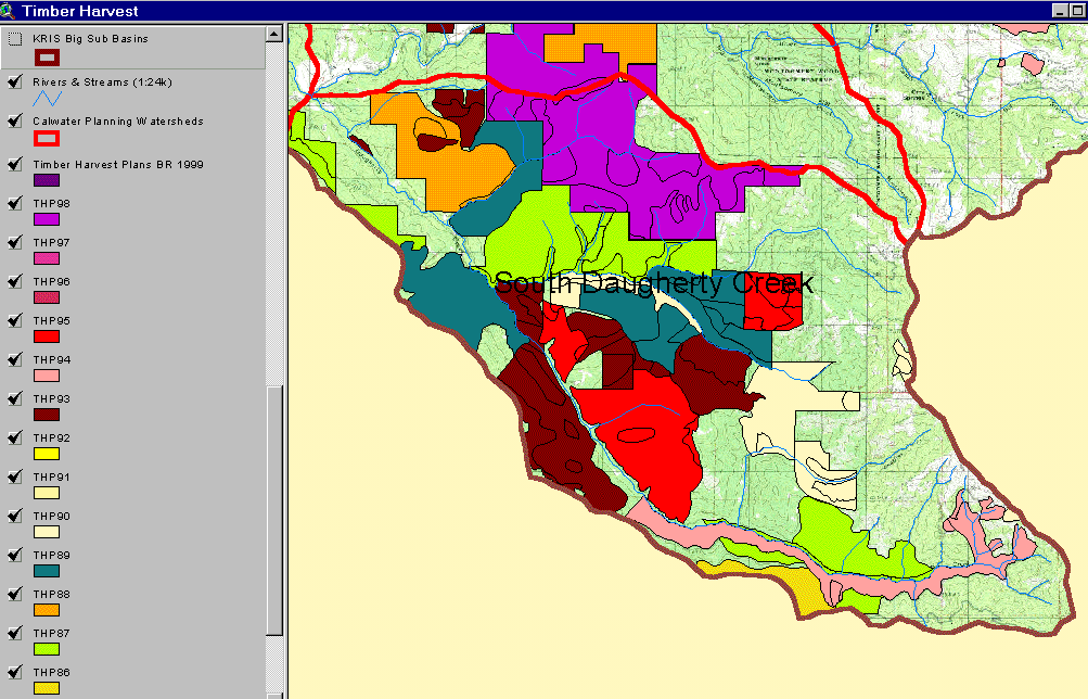 |
The image above comes from the KRIS Big River Map project and shows timber harvests as mapped by the California Department of Forestry by year from 1986 to 1999. The extensive logged areas correlate to the high amount of early seral stage vegetation in the South Daugherty Creek Calwater. (145 KB) |
References
Reeves, G.H., F.H. Everest and J.R. Sedell. 1993 . Diversity of Juvenile Anadromous Salmonid Assemblages in Coastal Oregon Basins with Different Levels of Timber Harvest. Transactions of the American Fisheries Society. Vol 122, No. 3. May 1993.
Schwind, B. 1999. USFS Thematic Mapper Landsat Vegetation Coverage Background Information. USDA Forest Service. Pacific Southwest Region Remote Sensing Lab. Sacramento, CA.
Warbington, R., B. Schwind, C. Curlis and S. Daniel. 1998. Creating a Consistent and Standardized Vegetation Database for Northwest Forest Plan Monitoring in California. USDA Forest Service. Pacific Southwest Region Remote Sensing Lab. Sacramento, CA.
![]()
| www.krisweb.com |