
|

|
| Background | Hypotheses | Bibliography | Maps | Home |
|
|
|
| Background | Hypotheses | Bibliography | Maps | Home |
Geology of the Ten Mile Basin
KRIS Web Background Pages: Geology of North Coastal California
![]()
Note: Geologic information, electronic maps and models within KRIS projects are meant to provide background information only and not as a decision making tool. California requires that licensed geologists be involved directly in decisions related to geologic conditions (see requirement).
The Ten Mile River basin is comprised principally of Coastal Belt Franciscan Formation which is different from the Central Belt Franciscan formation in that it lacks greenstone, serpentine and cherts (Kramer, 1974). The contact with the Central Belt Franciscan formation roughly follows the boundary of the Ten Mile basin to the east. Marine terraces of various ages form the western portion of the basin. The Sediment Source Analysis and Preliminary Sediment Budget for the Ten Mile River, Mendocino County, California by Matthews (2000) provides an excellent recap of geology and geomorphology of the Noyo Basin.
 |
The Ten Mile River estuary is surrounded by uplands comprised of marine terraces shown at left. The marine terrace has been uplifted and is composed of material that was once under the seafloor. Geologists classify this as an emergent coast; that is emerging from the ocean (Hardin, 1997). 275 KB |
|
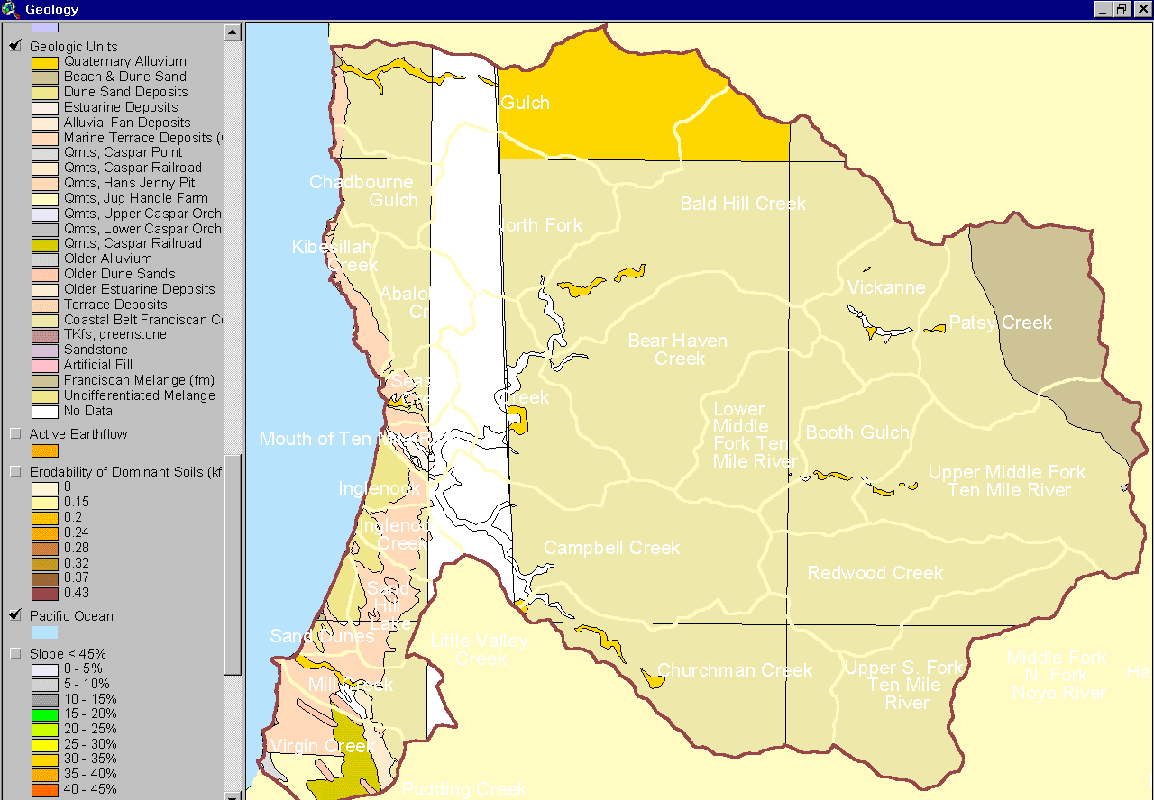
This map, from the KRIS Ten Mile Map project, shows the geology of the Ten Mile River basin. The information came from the California Division of Mines and Geology (Bedrosian, 1986). The material along the west is mostly uplifted marine sediment and sand dunes. The majority of the basin is comprised of Coastal Belt Franciscan Formation with alluvial materials found in river courses. The northeastern corner of the Ten Mile Basin in the North Fork basin near Patsy Creek is Central Belt Franciscan. This area has different vegetation and erodibility and it exhibited considerable mass wasting in the 1964 Flood. (See CDMG metadata). |
 |
This map came from came the California Division of Mines and Geology (Bedrosian, 1986) and shows landslides and active geologic areas. Like most Franciscan underlain watersheds, most of the basin is subject to landsliding. The is a high degree of conformance of this assessment with that of Matthews (2000) shown in the next image below. Taken from the KRIS Ten Mile Map project in ArcView. |
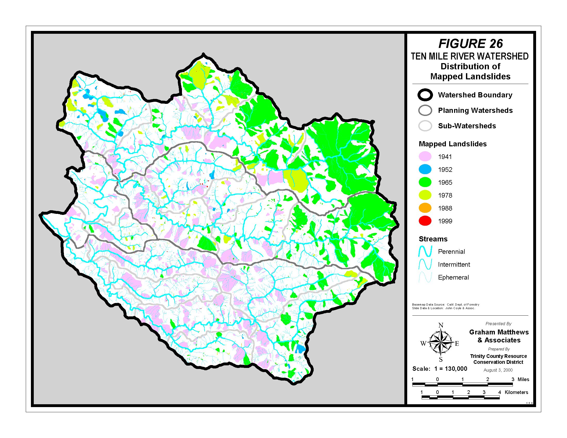 |
Matthews (2000) mapped active landslides from sequential aerial photos and they are displayed at left as Figure 26 from his report. The most active slides seem related to the first round of timber harvest in 1941 and following the 1964 storm. Slides in the northern portion of the basin were also extensive in the period prior to 1978. |
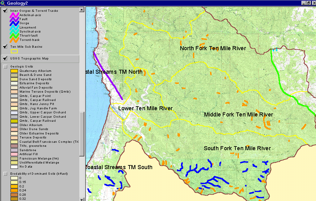 |
The image at left shows a trace of the San Andreas fault near the mouth of the Ten Mile and a thrust fault that forms the boundary of the Central belt Franciscan to the east. The debris torrents shown may be related to past logging activity. Only portions of the middle and upper South Fork basin have strongly formed inner gorge areas. Data from CDMG (Bedrosian, 1986). |
Work of Kramer (1974) is useful in understanding the Ten Mile basin, although his work was specifically focused on the neighboring Noyo watershed. He concluded that three primary forces were responsible for the formation of the Noyo basin landform and bedrock geology: 1) large undersea landslides which piled material up against the contact point of the Farallone and American plates which were colliding offshore of Ft. Bragg, 2) the plate collision itself and associated uplift, and 3) south trending compression on the American plate as the Triple Junction moved northward.
The bedrock of the Noyo Basin is largely sheared material and the Ten Mile basin has the same characteristics. Kramer (1974) noted with regard to the Noyo watershed that: "Because of the thick mantle of weathered rock, high rainfall, and steep slopes, surficial earthflows and mudflows are a very common occurrence in winter months. Nearly all road cuts and river channels exhibit evidence of rapid mass movement as a result of over-steepened slopes .The bedrock is highly fractured throughout the Coastal Belt and is subject to rockslides, slump and debris slides. Detailed studies in the Fort Bragg-Willits area, in relation to land development, have resulted in the conclusion that nearly all the rock is involved in either ancient or recent mass movement, and that any further road cuts or home site excavation will cause a given area to be subject to landsliding."
Landslide models of shallow debris slides, part of the KRIS Ten Mile Map project, confirm that risk of this type of slide is high in the upper Noyo (see Modeling Shallow Landslides ). Landslide risk is associated with slope and geologic terrain. For example, the Central Belt Franciscan mélange is prone to earthflows, where as the Coastal Belt Franciscan is much less susceptible to this type of mass wasting. Sub-basins with steeper slopes, such as the North Fork Ten Mile, are more subject to debris sliding. Matthews (2000) described all the potential sources of sediment in the Ten Mile Basin: "Sources of sediment in the Ten Mile watershed include mass wasting (deep-seated landslides, shallow-seated landslides or debris slides, and debris flows or torrents), surface erosion (hillslope erosion and road erosion), and fluvial erosion (gullying and stream bank erosion)." A full review of landsliding in the Ten Mile River Basin and its association with setting and land management can be reviewed in Matthews (2000).
The effects of the 1906 earthquake would have certainly extended to the Ten Mile River although the neighboring city of Ft Bragg was devastated by the quake. Oakshott (1972) provided an excellent account of the devastation of Ft Bragg and its rebound from the 1906 quake .
![]()
References
Bedrosian, T. L. 1986. Watershed Mapping in Northern California, an update. California Geology, February 1986.
Kramer, J.C. 1974. Geology and Tectonic Implications of the Coastal Belt Franciscan, Ft. Bragg-Willits Area, Northern Coast Ranges, California. U.C. Davis PhD. Dissertation, Davis, CA.
Matthews, G. 1999. Sediment Source Analysis and Preliminary Sediment Budget for the Noyo River. Graham Matthews and Associates, Weaverville, CA. (Contract 68-C7-0018. Work Assignment #0-18.) Prepared for Tetra Tech, Inc. Fairfax, VA.
Oakeshott, G.B. 1972. San Andreas Fault - Point Delgada to Ft. Ross. In: Geologic Guide to the Northern California Coast Ranges-Lake, Sonoma and Mendocino Counties, California: Annual Field Trip Guidebook of the Geological Society of Sacramento, 1972. p 83-93.
Short, Bill. California Division of Mines and Geology, Sacramento, CA. 916-322-4853
See a list of additional references at the California Division of Mines and Geology website: http://www.consrv.ca.gov/dmg.
![]()
| www.krisweb.com |