 |
Battle Creek Overview | Bibliography | Home | |
The purpose of the Battle Creek Watershed Assessment (WA) (Terraqua, 2004) was in part "to identify and prioritize for treatment sediment sources within Battle Creek." Watershed disturbance on unstable soil types is recognized as having greater potential for sediment yield; consequently, rhyolite areas were examined as part of the Battle Creek WA. Terraqua (2004) findings are summarized below.
The
U.S. Forest Service (Napper, 2001) noted that rhyolitic soils in the upper South
Fork Battle Creek watershed tend to have a moderate to high erosion hazard
rating, which increases based on slope. As vegetation is disturbed the erosion
potential increases
Concentration of water on these slopes may result in deep
gullies, and mass failures. Maintaining adequate effective ground cover is important
to preventing accelerated erosion and to reducing displacement. Road construction
and road drainage is important for these soils so to prevent accelerated erosion.
Another USFS study (Armentrout et al., 1998) of the Mill, Deer and Antelope
Creek watersheds, which are adjacent to
Findings of Battle Creek Watershed Assessment
The Battle Creek WA described the increased erosion risk on rhyolite:
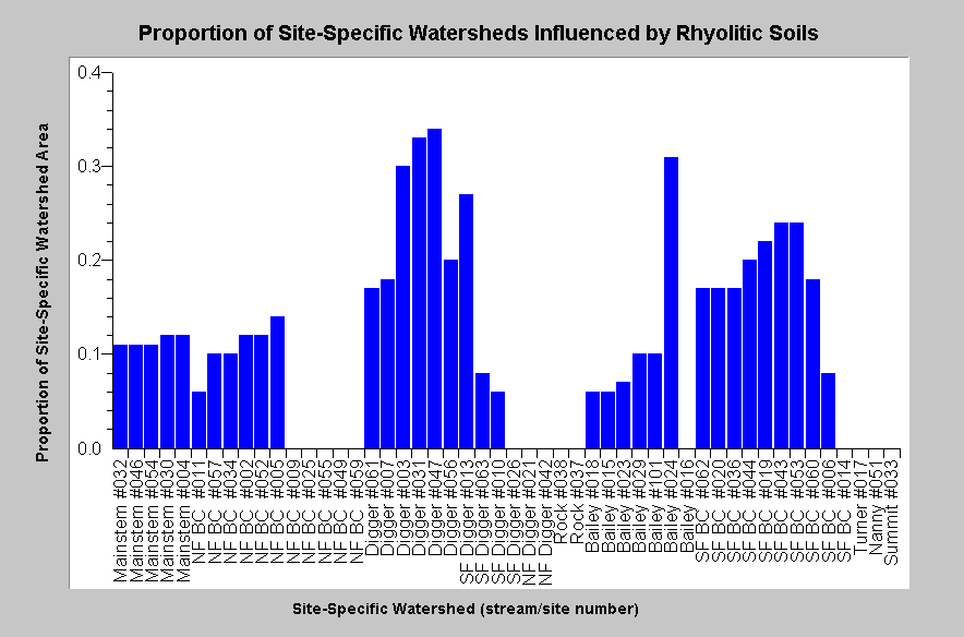
"Rhyolitic soils are recognized as being the most erodible soil type in the Battle Creek watershed (Napper 2001) and in the watersheds of Mill, Deer and Antelope creeks to the south (Armentrout et al. 1998). Data on the distribution of rhyolitic soils were obtained from the Chico State University and were digitized from U.S. Geologic Survey maps or incorporated from USFS surveys. The proportion of each site-specific watershed influenced by rhyolitic soils was calculated as the area of overlap between the individual site-specific watershed and rhyolitic soils polygons divided by the site-specific watershed area."
|
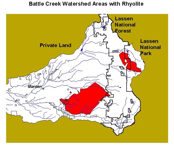
This chart shows the percentage of various Battle Creek WA sub-basins that are comprised of rhyolite. "Approximately 11 percent of the Battle Creek watershed is dominated by rhyolitic soils. Rhyolitic soils are generally located in upper Manzanita and North Fork Bailey Creeks and in the vicinity of Blue Ridge which is drained by Soap, Panther, and South Fork Digger Creeks. These soils occurred within 36 of 51 site-specific watersheds. Rhyolitic soils covered an average of 11 percent (± 11 SEM; range 0 to 34%) of the area within 51 site-specific watersheds" (Terraqua, 2004). Chart from KRIS Battle Creek V 2.0. |
Terraqua (2004) used statistical power analysis to test for relationships between areas in rhyolitic soils and aquatic monitoring results, but found no relationship to surface fine sediment, median particle size, pool frequency or pool depth.
|
The
major upcrops of rhyolite in the |
|
Related
Pages
|
|
| Battle Creek Overview | KRIS General Background |
| Battle Creek Sediment and Salmonid Habitat | |
![]()
References
Armentrout, S., H. Brown, S. Chappell, M. Everett-Brown, J. Fites, J. Forbes, M. McFarland, J. Riley, K. Roby, A. Villalovos, R. Walden, D. Watts, and M.R. Williams, 1998. Watershed Analysis for Mill, Deer, and Antelope Creeks. U.S. Department of Agriculture. Lassen National Forest. Almanor Ranger District. Chester, CA. 299 pp. [6.0 Mb]
Napper, C. O., 2001. Cumulative Watershed Effects - Battle Creek. Analysis of beneficial uses and water quality criteria to evaluate CWE susceptibility. U.S. Department of Agriculture, Forest Service, Lassen National Forest . Susanville, CA. 22 pp. [92 kb]
Terraqua, Inc. 2004. Battle Creek Watershed Assessment :Characterization of stream conditions and an investigation of sediment source factors in 2001 and 2002. Performed under contract to the Battle Creek Watershed Conservancy, Manton, CA. Funds from the Anadromous Fisheries Restoration Program and U.S. Fish and Wildlife Service under Agreement DCN: 11330-1-J113.
![]()
| www.krisweb.com |