
| Area | Arroyo Corte Madera |
| Topic | Sediment: Road Densities in the Arroyo Corte Madera Sub-Basin |
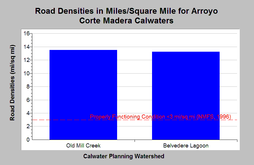
| Caption: The chart shows road densities in mile per square miles in Arroyo Corte Madera Calwaters. Both Calwaters have densities exceeding properly functioning condition according to the National Marine Fisheries Service (1996), which is less than 3 miles per square mile, a value shown for reference. Cedarholm, et. al. (1981) suggests that road densities should not exceed 1.6 mi/sq. mi. Roads in this sub-basin are mostly associated with urbanization. Roads densities calculated by KRIS IFR staff in Arc Info.Road data originates from 1:100,000 scale topographic maps and under represent road densities, especially in urban areas. Roads densities are calculated by KRIS IFR staff in Arc Info. Calwater full names are located in the Chart Table. Click Map to view the roads in the Arroyo Corte Madera sub-basin. See Info Links for more information. | |
 |
To learn more about this topic click Info Links .
To view additional information (data source, aquisition date etc.) about this page, click Metadata .
To view the table with the chart's data, click Chart Table web page.
To download the table with the chart's data, click roads_densities_arroyocortemadera_100k.dbf (size 260 bytes)
To download the table with the chart's data as an Excel spreadsheet, click roads_densities_arroyocortemadera_100k.dbf.xls (size 3,584 bytes) .
| www.krisweb.com |