|
Area/Topic | Bibliography | Background | Hypotheses | Home |
KRIS West Marin-Sonoma: Map Page
| Area | Drakes Bay |
| Topic | Land Cover: USFS Veg Size in Drakes Bay Sub-basin 1994 |
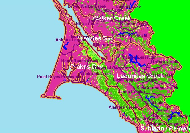
| This is the 1994 USFS Landsat vegetation and tree size map for the Drakes Bay sub-basin. Most of the western basin extending out to Point Reyes and around Drakes Estero is in grasslands, beach or rocky headlands, which show up as Non-Forest in this theme. Forests cover the hillslopes along the ridge extending south from Tomales Bay which extends down through the southern Drakes Bay sub-basin. Data provided by the U.S. Forest Service Spatial Analysis Lab in Sacramento, CA. The vegetation classification is accurate at a one-hectare scale (approximately 11 pixels) and is suitable for stand classification. Scale = 1:311,690 . | |||
![]() |
![]() |
||
To view metadata about a map layer, click on a link in the table below.
| Name of Layer in Map Legend | Metadata File Name |
|---|---|
| Calwater PWS (w/ labels) | calw22.shp.txt |
| Subbasins (w/ labels) | subbasins.shp.txt |
| Frame Project Outline | Unavailable |
| Lakes and Reservoirs (Marin only) | Unavailable |
| USFS Riparian Veg Size (1994) | vegsizebuf.tif.txt |
| USFS Vegetation Size (1994) | vegsize.tif.txt |
| Topo Map, North (1:24k scale) | Unavailable |
| Topo Map, South (1:24k scale) | Unavailable |
| Project Background | Unavailable |
| www.krisweb.com |