| Area | Lagunitas Creek |
| Topic | Fish: Spawner Survey, Coho Redds Basinwide 1997-2001 |
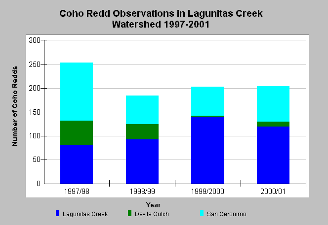
| Caption: The chart reflects spawner survey data provided by the Marin Municipal Water District (MMWD) for the Lagunitas Creek Watershed from 1997-2001. The coho redd observations are divided by mainstem and tributaries. Data were collected by MMWD, the National Park Service (NPS), and the Salmon Protection and Watershed Network (SPAWN). Access to Devils Gulch in low water years may be related to reduced spawning activity. Reach survey length in San Geronimo Creek may vary between years (Woodacre Cr added in 2000-01). See other topics for a breakdown of coho redd observations by reach. See Map for redd locations and Info Links for more information. | |
 |
To learn more about this topic click Info Links .
To view additional information (data source, aquisition date etc.) about this page, click Metadata .
To view the table with the chart's data, click Chart Table web page.
To download the table with the chart's data, click fish_spawneryearly_mmwd_1997_2001.dbf (size 4,022 bytes) .
To view the table with the chart's source data, click Source Table web page.
To download the table with the chart's source data, click fish_spawnerdaily_mmwd_1997_2001.dbf (size 53,914 bytes)
| www.krisweb.com |
