
| Area | Basin-wide/General |
| Topic | Sediment: 1999 Percent Fines <0.85 mm - Garcia Tribs, McBain&Trush |
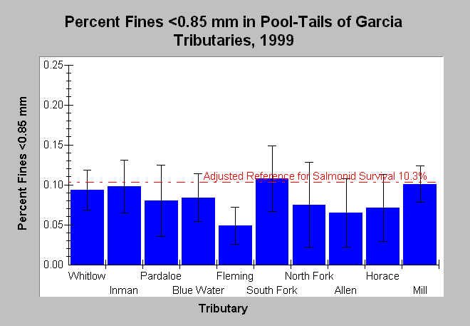
| Caption: This chart shows McNeil dry-sieve sample results as mean percent fines <0.85 mm with standard error bars from samples sites of ten Garcia River tributaries in 1999. The reference is adjusted for dry-sieve analysis from the Garcia River TMDL (U.S. EPA, 1998) reference of 14% (wet sieve) for percent fines <0.85 mm using methods of Shirazi and Seim (1979). Fines in this size class were highest in the South Fork Garcia, but lowest in its tributary Fleming Creek. See tributary basin Topics for a breakdown of samples by location. See InfoLinks for more information. | |
 |
To learn more about this topic click Info Links .
To view additional information (data source, aquisition date etc.) about this page, click Metadata .
To view the table with the chart's data, click Chart Table web page.
To download the table with the chart's data, click sed_mcbain_perm_f085_tribs.dbf (size 948 bytes) .
To view the table with the chart's source data, click Source Table web page.
To download the table with the chart's source data, click sed_mcbain_site.dbf (size 16,039 bytes)
| www.krisweb.com |