

| |
|
| Background | Hypotheses | Bibliography | Maps | Home |
Timber Harvest Information in KRIS Gualala
KRIS Web Background Pages: Vegetation Types
![]()
The 1994 Landsat imagery, processed by the U.S. Forest Service Southwest Region Remote Sensing Lab, is available in the KRIS Gualala Map project and summary results are also displayed as charts in the KRIS database. Landsat imagery for most other areas of the State is also available (Warbington et al., 1998; Schwind, 1999). These data allow a quick review of seral stages in various Calwater planning units. The USFS classification system, which uses ten size classes, but not tree type, was chosen. Tree size was then used as a surrogate for seral stage. Timber harvest data from the California Department of Forestry (CDF) is also incorporated into KRIS Gualala Maps, although coverage is restricted to 1991 to 2001. These can be used in conjunction with the USFS vegetation classification to explore patterns of watershed disturbance.
To some degree vegetation patterns in the Gualala basin are driven by geology, with grasslands, oak woodlands and mixed oak-fir forests occurring in the eastern part of the watershed, which is underlain by the Central Belt Franciscan formation. The Ohlsen Ranch formation in the upper South Fork and western Wheatfield also have similar vegetation type. The Coastal Belt Franciscan formation lies in the west of the watershed and provides the best forest soils.
The Fire and Resource Assessment
Program (FRAP) of CDF has recently completed a project that shows the changes
in the landscape between 1994 and 1998, based on Landsat data. This process,
called change scene detection, is very useful in KRIS Map projects because it
helps update vegetation coverages that were based on 1994 imagery. The rapidity
of change in vegetation of the Gualala River watershed landscape makes the 1994-1998
interval particularly useful for analysis.
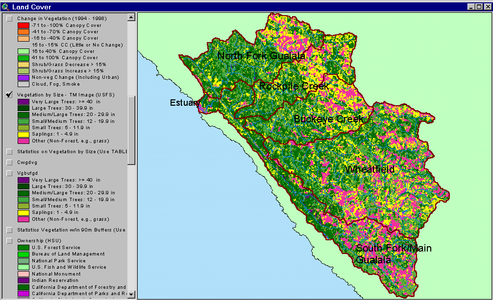 |
The USFS vegetation classification of the Gualala basin in 1994 is displayed at left. The eastern part of the Gualala basin is underlain by Central Belt Franciscan terrain and is, therefore, naturally in grasslands, oak woodlands and mixed oak and coniferous forest. The Ohlsen Ranch terrain in the eastern portion of the upper South Fork and southwestern Wheatfield subbasins also has similar vegetation patterns. The best coniferous timberland is in the lower South Fork and in the western portions of the Wheatfield, Buckeye, Rock pile and North Fork basins but tree diameters are small due to continuous timber harvests. Almost no large diameter conifers remain in the Gualala, except in the Middle South Fork Gualala Calwater and western Haupt Creek. |
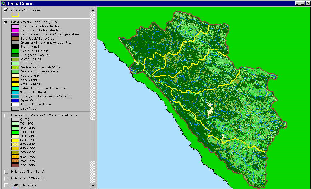 |
The EPA Land Cover project at left shows the same vegetation patterns as the USFS coverage above, but with different color signatures. This coverage is often used to detect effects of urbanization with shades of purple denoting residential, commercial or industrial development. Only small patches of near the town of Gualala are given codes associated with development. Patches of mixed forest and shrubland in the central and western portion of the watershed reflect early seral conditions after timber harvest. |
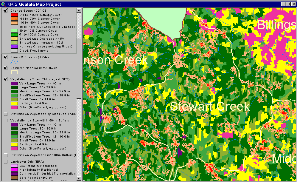 |
Changes in vegetation between 1994 and 1998 based on Landsat imagery are displayed at left for the Stewart Creek Calwater. Changes in canopy were mostly in the direction of canopy reduction, indicating intense timber harvest over a substantial area in just four years. |
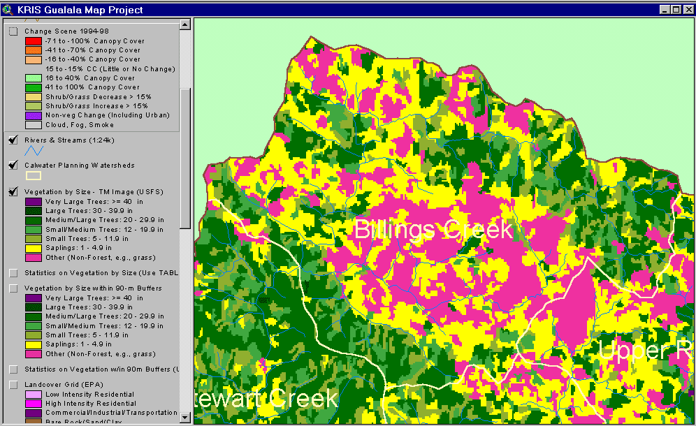 |
The image at left shows USFS vegetation stand types based on a 1994 Landsat image for the Billings Creek Calwater planning watershed in the eastern North Fork basin. This area is in the Central Belt Franciscan and has natural components of small trees and grasslands (Non-Forest). See the photo below to compare spectral signatures with actual vegetation patterns. |
 |
This photo was taken in the Billings Creek watershed, upper North Fork Gualala River basin, and shows the vegetation pattern that gives rise to the Landsat image above. Conifers are sometimes concentrated in the draws or on hillsides in mixed forest with oak. Oaks may also grow on the edge of prairies or as isolated trees in the grasslands. |
 |
This bar chart shows vegetation and timber types of the Billings Creek Calwater planning watershed. The chart is skewed towards the right, indicating small diameter trees and non-forest, which is expected given the underlying geology and natural prairies that occur in this area. See Vegetation Background page for size classes. |
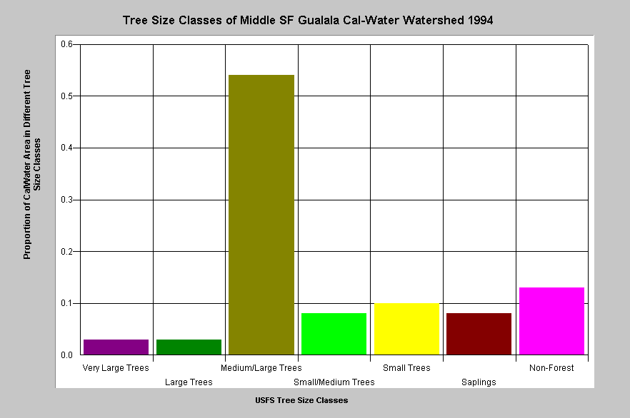 |
Vegetation and timber types of the Middle SF Gualala Calwater planning watershed are displayed at left. This Calwater has some of the last significant stands of Very Large Trees (40-50") and Large Trees (30-39.9" diameter) in the Gualala watershed and Medium/Large Trees (20-29.9" diameter) make up more than half the cover. Because this Calwater has the highest amount of mature timber in the Gualala basin, the graph is skewed toward the left. |
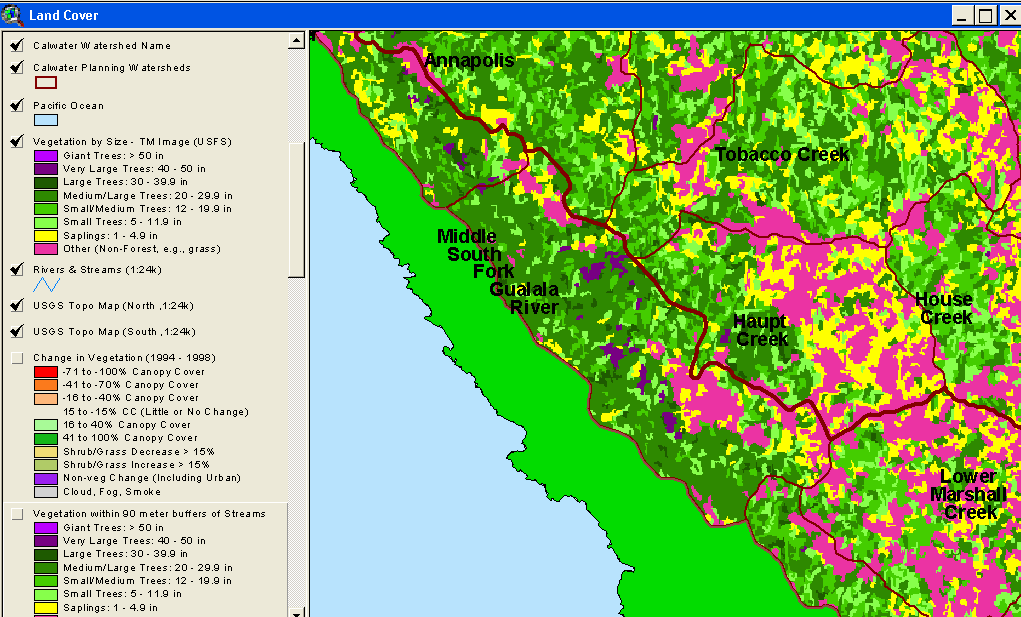 |
The image at left shows a close up of the Middle South Fork Gualala Calwater and USFS vegetation and tree size classes. Some of the last significant stands of Very Large Trees (40-50" diameter) in the Gualala watershed, as indicated by the patches of purple, are in this area. Intact forest provides clean, cold water. Patches of Non-Forest and Saplings (trees <5") in the eastern part of the Middle SF Calwater are in part owing to underlying patches of the Ohlsen Ranch formation. |
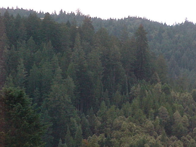 |
A patch of very old and large diameter trees at left abutting a second growth forest with mixed hardwoods and conifers is displayed in the photo at left. This grove is in the western part of Haupt Creek and the large trees are visible in the Landsat above as dark purple while the adjoining stand is in shades of green according to smaller average tree diameter. Photo courtesy of Dave Hope, North Coast Regional Water Quality Control Board. |
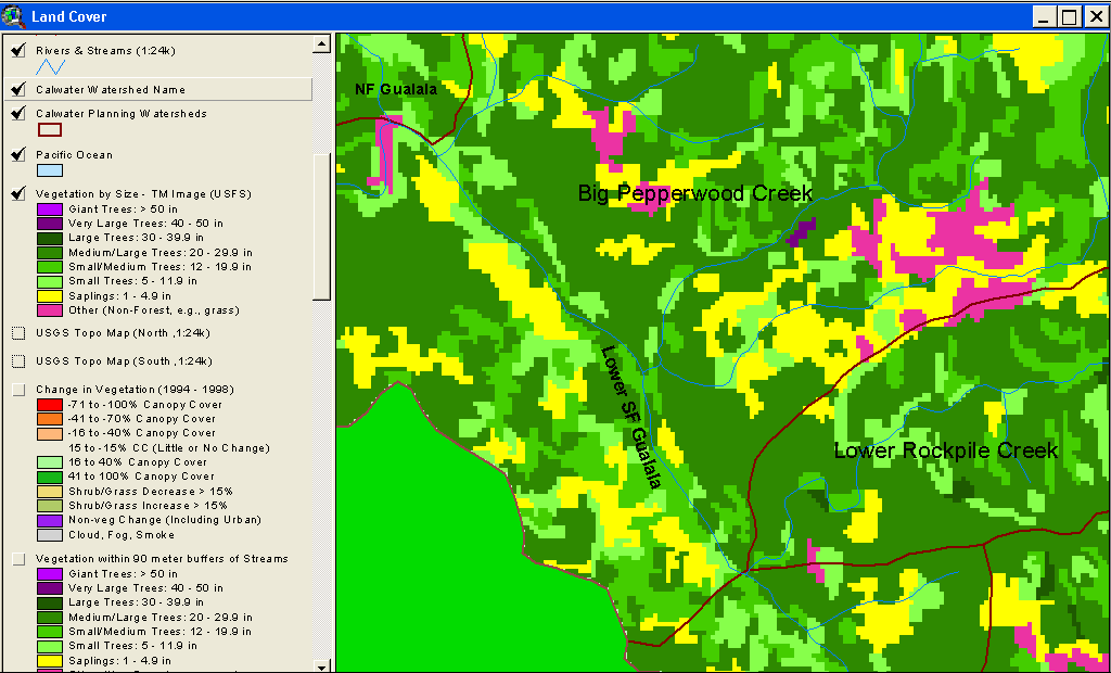 |
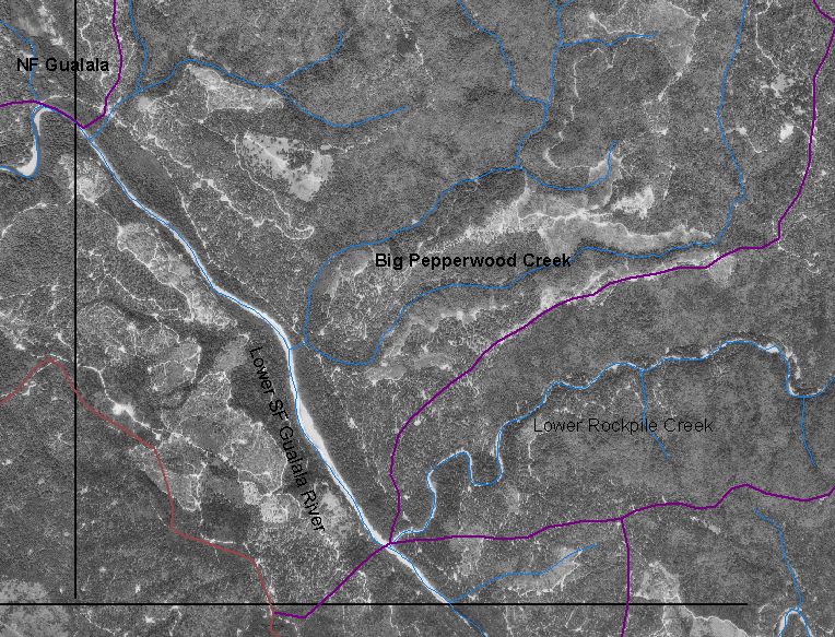
The image at left shows USFS vegetation and stand types for the lower Big Pepperwood Creek and lower South Fork Gualala watershed. The 1994 Landsat shows substantial components of. Non-Forest and Saplings (trees <5" diameter), mostly associated with recent timber harvest, which can be viewed on the photo below. Timber harvest patterns associated with early seral stages can be correlated to the THP map also shown below. |
 |
A 1996 orthophoto from the U.S. Geologic survey displayed at left shows extensive clear cut timber harvesting that matches with early seral stage signatures on Landsat in figure above. The orthophotos are equivalent to 1:24000 USGS topographic maps in size and have a resolution of 1 meter. The KRIS IFR team compresses them (using Mr. Sid) to make them small enough for use in the KRIS Gualala map project. |
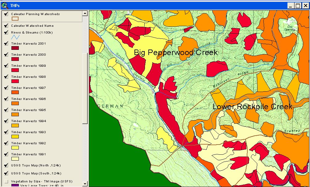 |
Timber harvests from 1991 to 2001 in the lower Big Pepperwood and lower South Fork Gualala are displayed at left. Notice the association of some areas mapped for harvest and early seral stage conditions and on the vegetation map. Timber harvests sometimes take place several years after approval, which may explain why some units mapped still show larger diameter timber. Also, early seral stage vegetation may occur in areas not mapped at left because harvests were approved between 1985 and 1990, periods not mapped by CDF. |
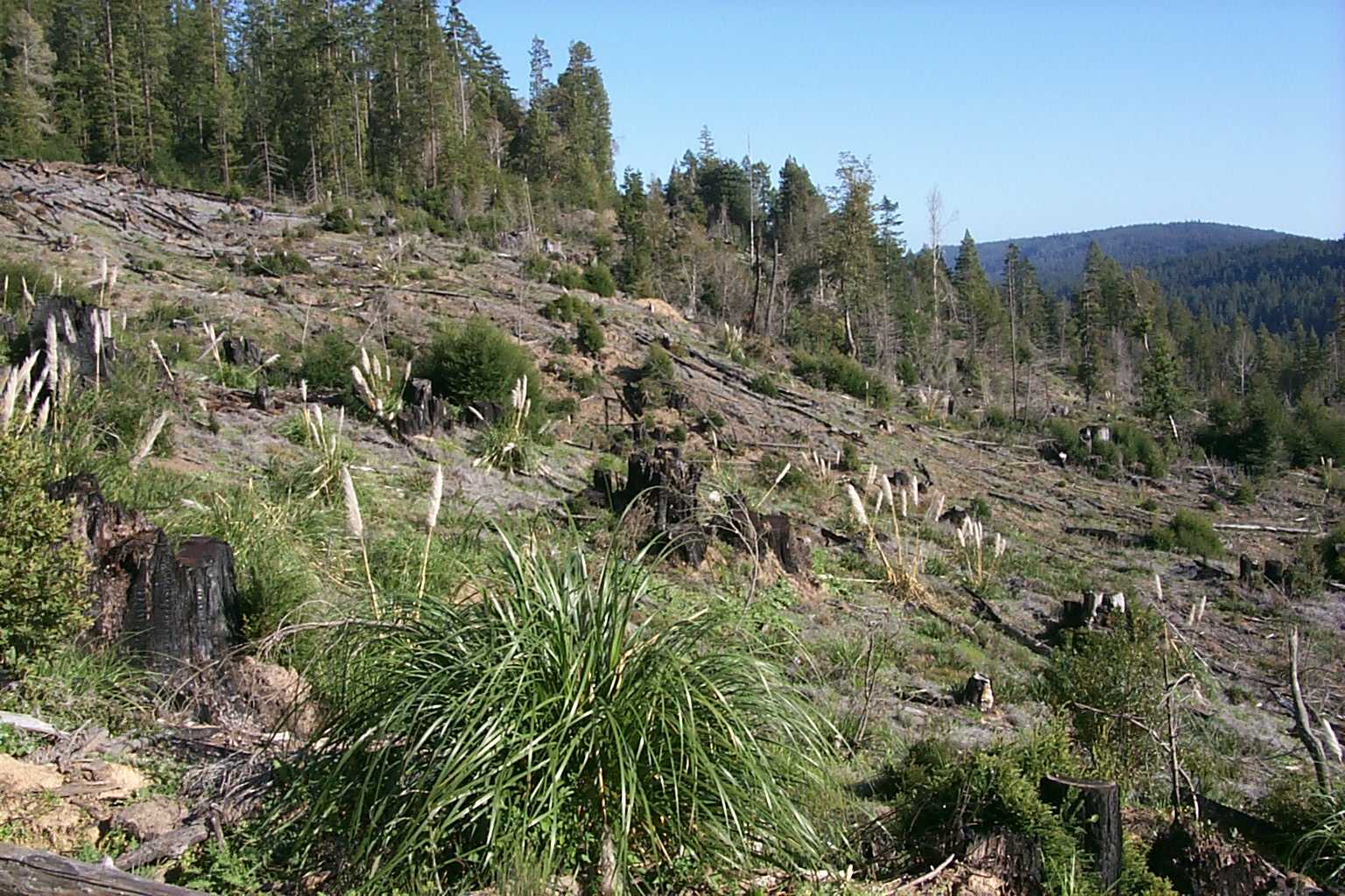 |
This photo shows vegetation regeneration after a clear cut with grasses, pampas grass, ceanothus, small trees and bare soil. The Landsat vegetation coverage would interpret this landscape as Non Forest. As trees grew in size, the next phase would be Saplings (trees <5" diameter). |
![]()
References
Schwind, B. 1999. USFS Thematic Mapper Landsat Vegetation Coverage Background Information. USDA Forest Service. Pacific Southwest Region Remote Sensing Lab. Sacramento, CA.
Warbington, R., B. Schwind, C. Curlis and S. Daniel. 1998. Creating a Consistent and Standardized Vegetation Database for Northwest Forest Plan Monitoring in California. USDA Forest Service. Pacific Southwest Region Remote Sensing Lab. Sacramento, CA.
![]()
| www.krisweb.com |