
| Area | North Fork |
| Topic | USFS Riparian Tree Size Classes: Robinson Creek CalWater 1994 |
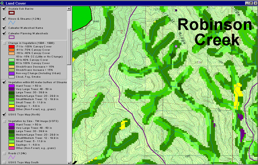
The image above shows USFS vegetation stand types for the riparian zone of Robinson Creek itself, as opposed to the larger Calwater area, which includes Dry Creek. The vegetation types and timber size classes are based on a 1994 Landsat image classified by the USFS Spatial Analysis Lab in Sacramento. The stand types are only accurate at the one-hectare scale and the buffer width is 90 meters on each side of the stream. Although the 1994 vegetation classification shows on 47% of the riparian as Medium/Large Trees (20-29.9" diameter) in the Robinson Creek Calwater, they appear to be more prevalent along Robinson Creek itself, particularly its tributaries. Note that more large trees are often present on just one side of the stream. CDF has often protected one side of the stream more than the other to maintain shade over the stream. Some large wood in the 90-meter zone of the Robinson Creek was also harvested between 1994 and 1998 (see Picture #2). See Info Links for more information. Taken from the KRIS Gualala Map project.
This image is the same as Picture #1, showing Robinson Creek with a 90 meter buffer riparian zone based on Landsat, but in this view the change in vegetation between 1994 and 1998 is also presented. The "change scene detection" is provided by CDF FRAP and is based on the same 1994 Landsat imagery as the USFS classification but also a 1998 Landsat. Red and orange indicate that the canopy cover has been reduced substantially. Intensive timber harvests within a 90-meter buffer is evident in headwaters of Robinson Creek tributaries. While disturbances of these ephemeral streams do not affect stream temperature directly, it does tend to increase sediment yield. Such harvests will also reduce large wood recruitment to areas downstream in the event of a landslide or debris torrent. The latter is a common mechanism for large wood delivery to streams and the large wood entrained in the slides catches up in jams metering sediment delivery and buffer some reaches downstream from impacts. Map image copied from the KRIS Gualala Map project.
The riparian vegetation in the Robinson Creek Calwater shows that McGann Creek (dog-leg right at lower center of Calwater) is dominated by small size classes of trees, Dry (upper right) and Robinson (mid-left) Creek riparian zones have more than their share of Medium/Large Trees (20-29.9 inch diameter) while the lower North Fork Gualala itself is dominated by smaller trees. Data from USFS Spatial Analysis Lab Sacramento as copied from the KRIS Gualala Map project.
As of 1994, the Dry Creek riparian zone had a substantial component of Medium/Large Trees (20-29.9 inch diameter), with some Very Large Trees (30-39.9") also showing up in small patches near the convergence with the North Fork Gualala and in an eastern tributary. See Picture #5 to see 1994-1998 Landsat change scene detection for Dry Creek riparian areas. Data from USFS Spatial Analysis Lab Sacramento as copied from the KRIS Gualala Map project.
This image is the same as Picture #4, showing Dry Creek with a 90 meter buffer riparian zone based on Landsat, but in this view the change in vegetation between 1994 and 1998 is also presented. The "change scene detection" is provided by CDF FRAP and is based on the same 1994 Landsat imagery as the USFS classification but also a 1998 Landsat. Red and orange indicate that the canopy cover has been reduced substantially. Intensive timber harvests within a 90-meter buffer is evident throughout the Dry Creek watershed. These harvests are likely to negatively affect large wood recruitment. Map image copied from the KRIS Gualala Map project.
As of 1994, the riparian zone of the lower mainstem North Fork Gualala had only patches of Medium/Large Trees (20-29.9 inch diameter) and instead had substantial reaches dominated by Small Trees (5-11.9 " diameter) and Small/Medium Trees (12-19.9" diameter). Yellow shows where Saplings (<5 ") predominate, which includes Class III streams. See Picture #7 to see 1994-1998 Landsat change scene detection for this area of the North Fork Gualala riparian zone. Data from USFS Spatial Analysis Lab Sacramento as copied from the KRIS Gualala Map project.
This image is the same as Picture #4, showing Dry Creek with a 90 meter buffer riparian zone based on Landsat, but in this view the change in vegetation between 1994 and 1998 is also presented. The "change scene detection" is provided by CDF FRAP and is based on the same 1994 Landsat imagery as the USFS classification but also a 1998 Landsat. The gray is the area of the 1998 image, which was shrouded in fog. Red and orange indicate that the canopy cover has been reduced substantially. Intensive timber harvests within a 90-meter buffer is evident in small order tributaries and in patches along the main North Fork Gualala itself. These harvests are likely to negatively affect large wood recruitment. Many of the areas with reduced vegetation are outside the immediate riparian zone but within the inner gorge above the North Fork. Map image copied from the KRIS Gualala Map project.
 Click on image to enlarge (163K).
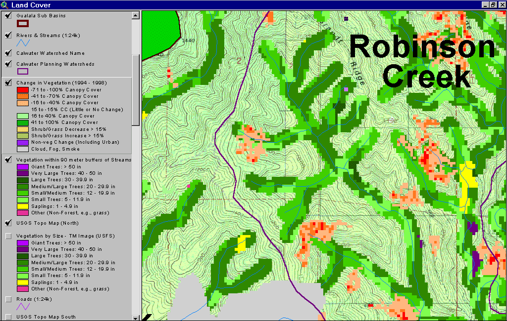 Click on image to enlarge (156K).
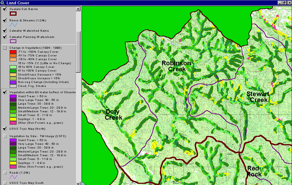 Click on image to enlarge (171K).
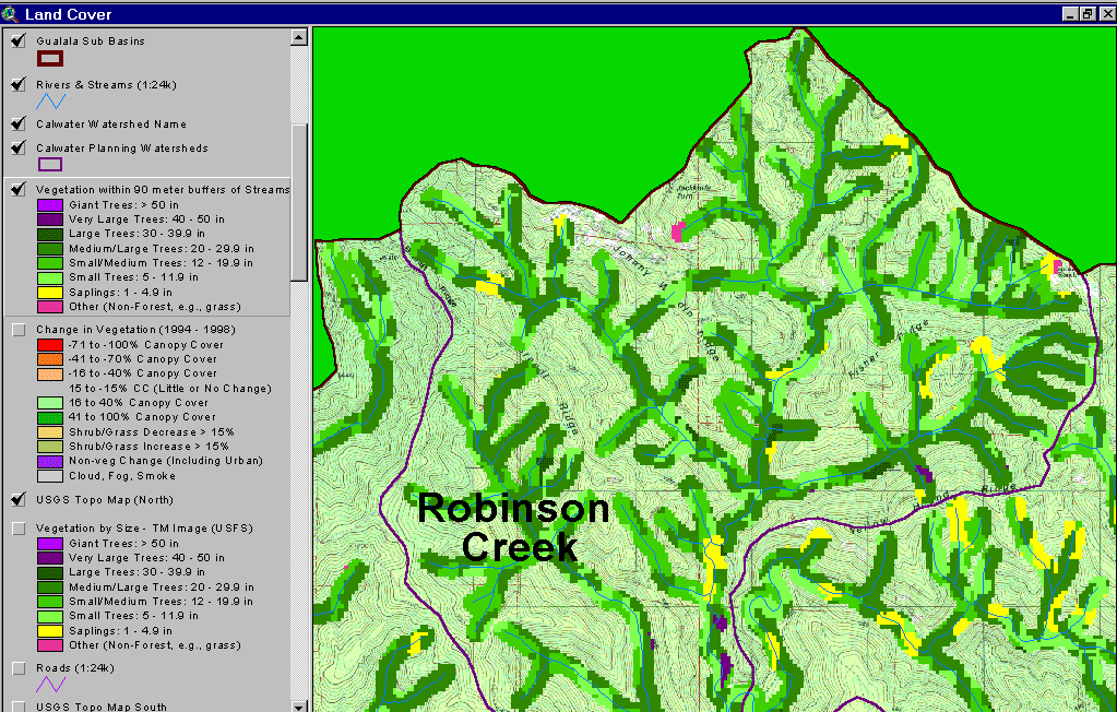 Click on image to enlarge (155K).
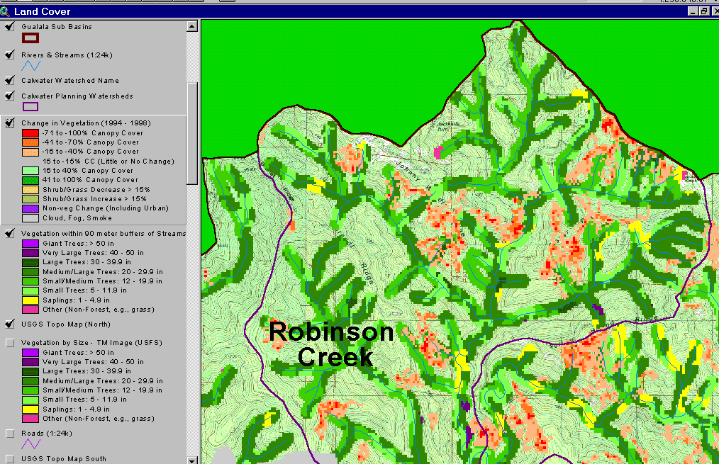 Click on image to enlarge (151K).
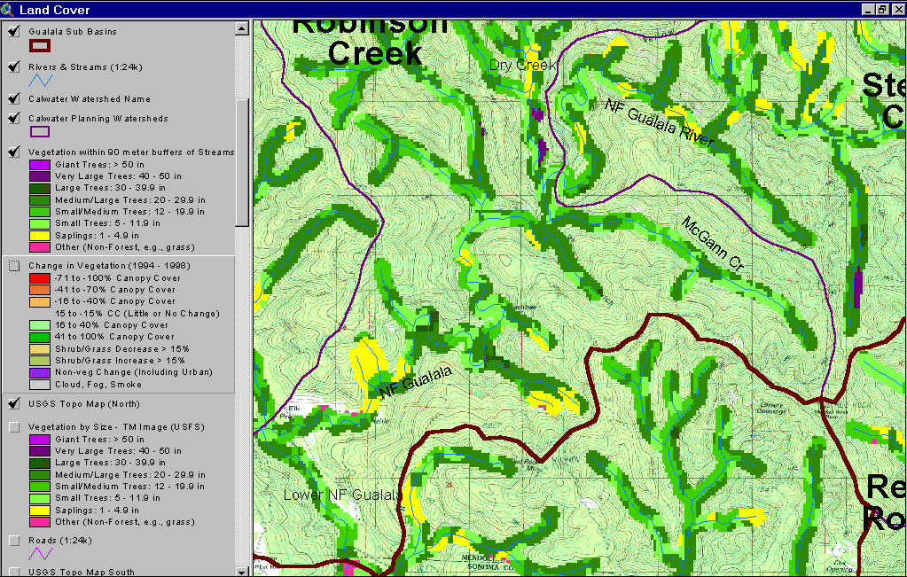 Click on image to enlarge (186K).
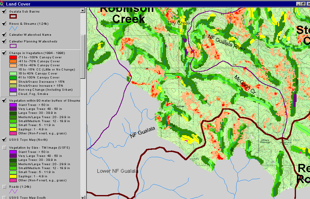 Click on image to enlarge (140K).
To learn more about this topic click Info Links
| www.krisweb.com |