
| Area | Middle Trinity |
| Topic | Timber Harvest: Lower Middle Trinity - Harvested Area through 2000 |
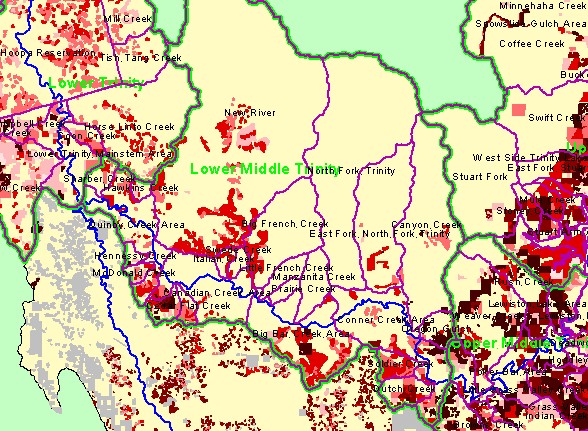
| This is a map of timber harvest from pre-1950 to 2001 in the sub-watersheds of the Lower Middle Trinity Planning Watershed, displayed with Trinity River and sub-basin outlines. Timber harvest was most intensive from 1950 to 1970, but has continued during more recent decades. No data from USFS (Six Rivers NF) or Hoopa Reservation harvests since 1977 were included in Lower Trinity. Data were produced by the Trinity County Resource Conservation District for the Graham Matthews and Associates Trinity River Sediment Source Analysis (2001). | |||
 |
 |
||
To view metadata about a map layer, click on a link in the table below.
| Name of Layer in Map Legend | Metadata File Name |
|---|---|
| Sub-Watersheds (TCRCD-GMA) | tr_wsbnd.shp.txt |
| Planning Watersheds (TCRCD-GMA) | tr_stdy-areas.shp.txt |
| Mainstem and South Fork Trinity | trin_riv.shp.txt |
| Timber Harvest, Mainstem Basins | tr_harvests_mrg.shp.txt |
| Timber Harvest by Decade, South Fork Basin | sf_harvests.shp.txt |
| Frame Project Outline | Unavailable |
| Change in Veget. (1994-98)(TIFF) | vegchg.tif.txt |
| Vegetation by DBH, Mainstem Basins (HSU 1994) (TIFF) | hsu_vegsize_n.tif.txt |
| Vegetation by DBH, South Fork Basin (HSU 1994) (TIFF) | hsu_vegsize_s.tif.txt |
| USFS Vegetation Size (1999)(TIFF) | vegsize99.tif.txt |
| USFS Vegetation Size (1994)(TIFF) | vegsize.tif.txt |
| Topographic Map (1:24k scale) | trinity.sid.txt |
| Topographic Map (1:24k scale) | trinity.sid.txt |
| Elevation (meters)(USGS)(TIFF) | elev30.tif.txt |
| Trinity Project Area | trin_outl.shp.txt |
| www.krisweb.com |