
|

|
| Background | Hypotheses | Bibliography | Maps | Home |
|
|
|
| Background | Hypotheses | Bibliography | Maps | Home |
Stream Flow
![]()
Stream flow or discharge is the volume of water flowing in a stream channel as measured by unit time (cfs = cubic feet per second) and is in many ways an important determinant of water quality and aquatic habitat conditions. High water temperature, low levels of dissolved oxygen, and deleterious levels of toxins can all be exacerbated by low stream flow. Moreover, the quantity, quality and connectivity (e.g. fish migration) of aquatic habitats are also influenced by flow. Agricultural and domestic water diversions are common sources of impact to aquatic resources. Diversions and associated diking, damming, and dredging have been shown to be a large contributing factor to the loss of salmon and steelhead habitat in some river basins (Beechie et al. 1994; Kier Assoc., 1991).
Stream flow is also a powerful determinant of aquatic habitat conditions through the effects of peak or flood events. All coastal watersheds of northern California exhibit, as a function of climate, highly variable and unpredictable or flashy stream flows during winter months. Only the highest 5% of the range of flows cause the stream channel to undergo significant morphological change as a function of deposition and scour (Leopold 1994, Matthews 1999). It is during these flood flows that banks are either built or eroded, pools are deepened or filled, and large wood is contributed and redistributed. It is also during these flood flows that very high rates of mortality occur for salmonids in the egg or alevin life stage (McHenry et al. 1994).
Changes to vegetation, such extensive clear cutting, can cause an increase in the frequency and intensity of flood flows by allowing accelerated runoff. Zeimer (1998) found a 35% increase in mean peak flows following logging of the North Fork of Caspar Creek. While this effect disappears with forest stand recovery, urbanization has a more profound effect on peak flows as a function of impervious surfaces (may et al., 1996). Both removal of vegetation and urbanization also have the effect of decreasing the lowest flows by reducing the water storage capacity of watershed soils.
|
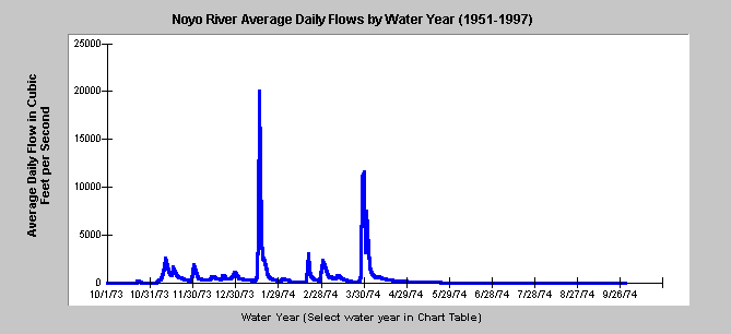
| This KRIS Noyo chart shows average daily flow of the Noyo River in cubic feet per second (cfs) for the year 1974, which had the highest flow of any year recorded since 1951. Flow data has been collected by the U.S. Geologic Survey since 1951 and all years are available for review in KRIS. |
Stream flow information in KRIS Noyo was provided by Matthews (1999) and is based on the Noyo River's one flow gauge, located 0.6 miles below the South Fork confluence, installed in 1952, and maintained by the U.S. Geologic Survey. The largest flood recorded for the Noyo River occurred in January 1974, when the river crested at 26,600 cfs. Other significant storms occurred in December 1955, December 1964, January 1993, January 1956, and December 1951. Although the Noyo has a relatively short period of stream flow records, known large flood events in the region or the watershed have occurred in 1861, 1881, 1890, 1906, 1914, 1938, 1956, 1965, 1966, 1974, and 1993. Matthews (1999) speculates that the largest of these were likely to have been the 1861 and 1890 events, followed by the 1914, 1938, and 1974 events. He notes that many of the largest floods have occurred in the last 50 years.
Noyo River flows are less than 32 cfs 50% of the time. The lowest stream flows are not always measured, but were likely to occur during the particularly dry periods of 1959-1964, 1976-1981, and 1987-1992.
The City of Fort Bragg draws its municipal water supply from the lower Noyo River. The facility was constructed in 1960, and also supplies the Georgia-Pacific Mill. Maximum pumping rate is 3.0 cfs. Concern about impacts on fisheries led the city to commission a study by Alice Rich in 1995. Preliminary results from the study indicate no effect on fisheries or fish habitat due to the downstream location of the pumping facility (Doug Albin, CDFG).
![]()
References
Beechie, T., E. Beamer, and L. Wasserman. 1994. Estimating Coho Salmon Rearing Habitat and Smolt Production Losses in a Large River Basin, and Implications for Habitat Restoration. North American Journal of Fisheries Management. 14:797-811.
Kier (William M.) Associates. 1991 . Long Range Plan for the Klamath River Basin Conservation Area Fishery Restoration Program. Klamath River Basin Fisheries Task Force. Yreka, CA.
Leopold, L. B. 1994. A View of the River. Harvard University Press. Cambridge, Massachusetts.
Matthews & Associates. 1999. Sediment source analysis and preliminary sediment budget for the Noyo River. Weaverville, CA. (Contract 68-C7-0018. Work Assignment #0-18.) Prepared for Tetra Tech, Inc. Fairfax, VA.
McHenry, M.L., D.C. Morrill, and E. Currence. 1994. Spawning Gravel Quality, Watershed Characteristics and Early Life History Survival of Coho Salmon and Steelhead in Five North Olympic Peninsula Watersheds. Port Angeles, WA. 59 pp. without appendices.
Zeimer, R. 1998 Flooding and Storm Flows. Proceedings of the conference on coastal watersheds: The Caspar Creek Story. USDA PSW http://www.psw.fs.fed.us/Tech_Pub/Documents/gtr-168/gtr168-toc.html
![]()
| www.krisweb.com |