
|

|
| Background | Hypotheses | Bibliography | Maps | Home |
|
|
|
| Background | Hypotheses | Bibliography | Maps | Home |
KRIS Web Background Pages: Geology
![]()
Note: Geologic information, electronic maps and models within KRIS Noyo are meant to provide background information only and not as a decision making tool. California requires that licensed geologists be involved directly in decisions related to geologic conditions (see requirement).
The Noyo River basin is comprised principally of Coastal Belt Franciscan Formation which is different from the Central Belt Franciscan formation in that it lacks greenstone, serpentine and cherts (Kramer, 1974). The contact with the Central Belt Franciscan formation roughly follows the boundary of the Noyo Basin to the east. Marine terraces of various ages form the western portion of the Noyo Basin. The Sediment Source Analysis and Preliminary Sediment Budget for the Noyo River by Matthews (1999) provides an excellent recap of geology and geomorphlogy of the Noyo Basin.
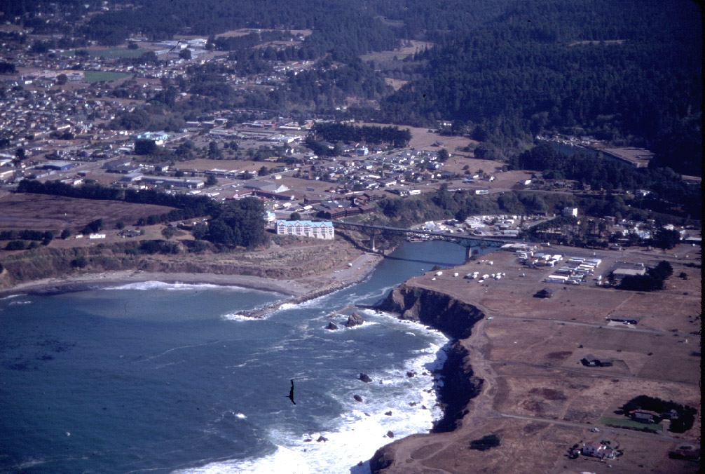 |
The City of Fort Bragg sits on a marine terrace shown here with the mouth of the Noyo River emerging from the rocky coastal bluffs. The marine terrace has been uplifted and is composed of material that was once under the seafloor. Geologists classify this as an emergent coast; that is emerging from the ocean (Hardin, 1997). 275 KB |
|
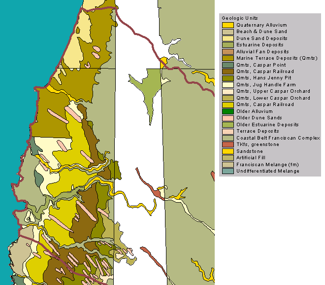
This
map, from the KRIS Noyo Map project, shows the geology of the terraces in
the western portion of the Noyo River basin. The information came from the
California Division of Mines and Geology (Bedrosian, 1986). The material
is mostly uplifted marine sediment and sand dunes. To the east is the Coastal
Belt Franciscan Formation. (See CDMG metadata).
27 KB |
Kramer (1974) concluded that three primary forces were responsible for the formation of the Noyo basin landform and bedrock geology: 1) large undersea landslides which piled material up against the contact point of the Farallone and American plates which were colliding offshore of Ft. Bragg, 2) the plate collision itself and associated uplift, and 3) south trending compression on the American plate as the Triple Junction moved northward.
The bedrock of the Noyo Basin is largely sheared material. Kramer (1974) noted that: "Because of the thick mantle of weathered rock, high rainfall, and steep slopes, surficial earthflows and mudflows are a very common occurrence in winter months. Nearly all road cuts and river channels exhibit evidence of rapid mass movement as a result of over-steepened slopes .The bedrock is highly fractured throughout the Coastal Belt and is subject to rockslides, slump and debris slides. Detailed studies in the Fort.Bragg-Willits area, in relation to land development, have resulted in the conclusion that nearly all the rock is involved in either ancient or recent mass movement, and that any further road cuts or homesite excavation will cause a given area to be subject to landsliding." Matthews (1999) concurred that mass wasting in the Noyo Basin associated with roads was a common occurrence.
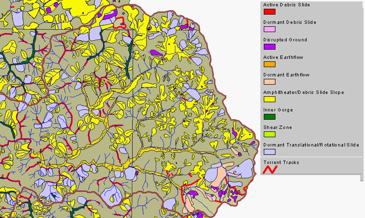 |
The geologic information in the KRIS Noyo Map project clearly illustrates the findings of Kramer (1974). These map layers were obtained from the California Division of Mines and Geology (Kilbourne 1983,1984). When all the layers from the CDMG project related to active and dormant features are viewed as a map composition, one can see that most of the landscape in the upper Noyo and North Fork Noyo watersheds has been influenced by landsliding. |
 |
This map, from the KRIS Noyo Map project, shows that the Coastal Belt Franciscan is the dominant rock type of the Noyo River basin. The Central Belt Franciscan borders the basin to the east and spills over in small portion of the upper Noyo basin forming a huge earthflow complex. The river channels and valley floors are dominated by alluvium. Data provided by the California Division of Mines and Geology (Bedrosian, 1986). This project was clipped to the Noyo basin and the color to the east (right) is a backdrop, not a rock type. (See CDMG metadata). |
Landslide models of shallow debris slides are also part of the KRIS Map project and confirm that risk of this type slide is high in the upper Noyo (see Modeling Shallow Landslides background page). Landslide risk is associated with slope and geologic terrane. For example, the Central Belt Franciscan melange is prone to earthflows, where as the Coastal Belt Franciscan is much less susceptible to this type of mass wasting. Sub-basins with steeper slopes, such as the North Fork Noyo, are more subject to debris sliding. Matthews (1999) described all the potential sources of sediment in the Noyo Basin: "Sources of sediment in the Noyo watershed include mass wasting (deep-seated landslides, shallow-seated landslides or debris slides, and debris flows or torrents), surface erosion (hillslope erosion and road erosion), and fluvial erosion (gullying and streambank erosion)." A full review of landsliding in the Noyo River Basin and its association with setting and land management can be reviewed in Matthews (1999). The California Division of Mines and Geology has also been compiling detailed landslide information for the Noyo River Basin which is due out by the end of summer 2000 (Bill Short, personal communication).
Although the San Andreas is offshore from Ft. Bragg and not on land, the effect of the 1906 earthquake on the city was still devastating. Oakshott (1972) provided an excellent account of the devastation of Ft Bragg and its rebound from the 1906 quake .
![]()
References
Bedrossian, T. L. 1986. Watershed Mapping in Northern California, an update. California Geology, February 1986.
Kramer, J.C. 1974. Geology and Tectonic Implications of the Coastal Belt Franciscan, Ft. Bragg-Willits Area, Northern Coast Ranges, California. U.C. Davis Phd. Dissertation, Davis, CA.
Matthews, G. 1999. Sediment Source Analysis and Preliminary Sediment Budget for the Noyo River. Graham Matthews and Associates, Weaverville, CA. (Contract 68-C7-0018. Work Assignment #0-18.) Prepared for Tetra Tech, Inc. Fairfax, VA.
Oakeshott, G.B. 1972. San Andreas Fault - Point Delgada to Ft. Ross. In: Geologic Guide to the Northern California Coast Ranges-Lake, Sonoma and Mendocino Counties, California: Annual Field Trip Guidebook of the Geological Society of Sacramento, 1972. p 83-93.
Short, Bill. California Division of Mines and Geology, Sacramento, CA. 916-322-4853
See a list of additional references at the California Division of Mines and Geology website: http://www.consrv.ca.gov/dmg.
![]()
| www.krisweb.com |