
|

|
| Background | Hypotheses | Bibliography | Maps | Home |
|
|
|
| Background | Hypotheses | Bibliography | Maps | Home |
![]()
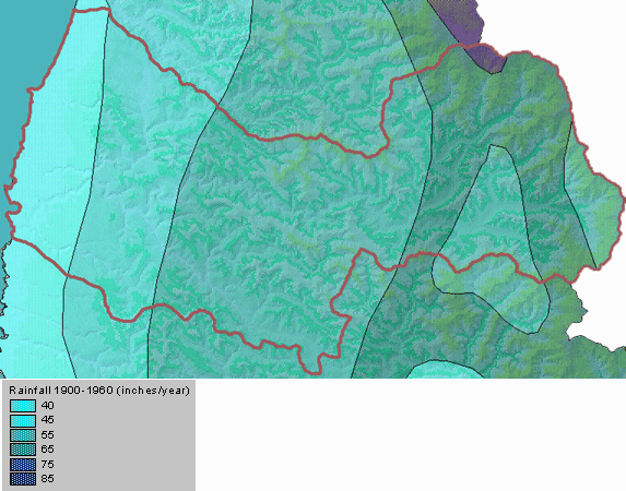
Data on precipitation in KRIS is taken from Matthews (1999) which captured rainfall data from the California Department of Water Resources rain gauges at Fort Bragg and Willits. Historic data was assimilated by James Goodridge, former state climatologist and now consultant to the California Department of Water Resources. Because Willits is actually slightly east of the Noyo River basin, exact rainfall patterns in the basin are unknown. Estimates of rainfall distribution are available as part of the KRIS Noyo Map project in the form of isopleths.
|
Although there are no permanent rainfall gauges in the upper Noyo River watershed, rainfall estimates have been calculated which indicate that rainfall ranges from 40 inches per year at the coast to over 70 inches per year in the upper watershed. This view is taken from the KRIS Noyo Map project. |
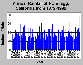
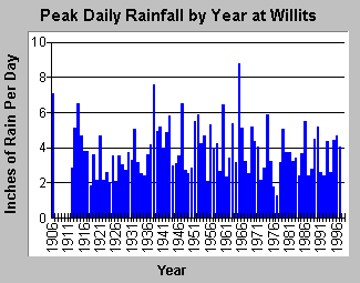
Rainfall on the coast at Fort Bragg averages just under 39 inches per year while Willits annual rainfall averages 51 inches, although in some years rainfall may actually be higher on the coast than in Willits. One of the most important factors influencing erosion and sediment impacts to streams is rainfall intensity. The lack of gauges makes it difficult to determine intensity but Matthews (1999) used peak daily rainfall as an indicator of this factor. Rainfall peaks at Ft Bragg do not seem to be as indicative of peak rainfall intensity in the upper Noyo basin or of peak stream flows as rainfall maxima at Willits. For example, while peak daily rainfall in 1964 and 1974 at Fort Bragg were not particularly high, flows for those years were some of the highest recorded. Matthews (1999) postulated that the highest flows on record in 1974 may have been influenced by a rain on snow event.
|
|
| The chart above is taken from KRIS Noyo and shows the total annual rainfall at Fort Bragg from 1986 to 1999. The highest rainfall total of 80 inches was recorded in 1998. Data from CDWR and Matthews (1999). | Maximum daily rainfall at Willits by year is shown above in a chart taken from the KRIS Noyo database. Matthews (1999) used peak daily rainfall at Willits to judge periodicity of peak flows of the Noyo River. The highest daily total was during the 1964 flood. |
![]()
References
Matthews, G. 1999. Sediment Source Analysis and Preliminary Sediment Budget for the Noyo River. Graham Matthews and Associates, Weaverville, CA. (Contract 68-C7-0018. Work Assignment #0-18.) Prepared for Tetra Tech, Inc. Fairfax, VA.
![]()
| www.krisweb.com |