
|

|
| Background | Hypotheses | Bibliography | Maps | Home |
|
|
|
| Background | Hypotheses | Bibliography | Maps | Home |
KRIS Web Background Pages: Roads and Erosion
![]()
Road densities in KRIS Ten Mile are taken from Matthews (2000) and were calculated from aerial photographs taken at different time periods and from California Department of Forestry (CDF) information about recent timber harvest plans that include new roads. Road density values in KRIS are compared to a threshold of 3 miles of road per square mile, which is taken from the National Marine Fisheries Service (1996) working guidelines for salmon conservation. The guidelines characterize watersheds over this threshold as "at risk" or "not properly functioning". Road data is available in the KRIS Ten Mile Map project from the California Department of Forestry and Matthews (2000). Mapping of road construction by Matthews (2000) was based on aerial photo analysis dating from 1942 to 1988 and roads constructed since 1988 assimilated from data provided by CDF. Summary road data from Matthews (2000) are also available in the KRIS Ten Mile database as charts tables.
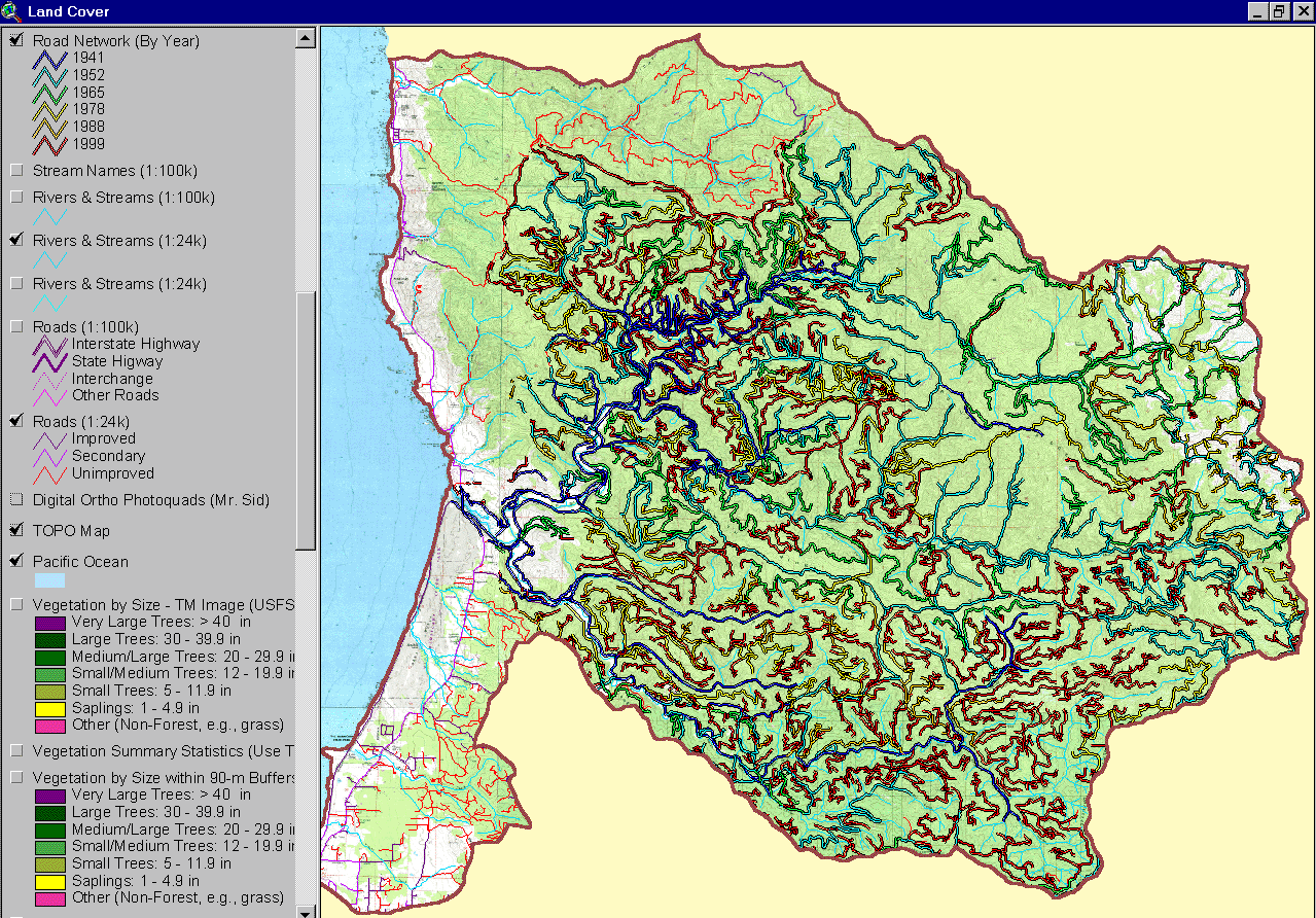 |
This image of a map, assimilated into the KRIS Ten Mile Map Project from Matthews (2000), shows road construction by period. According to Matthews (2000): "there are currently 940 miles of roads in the Ten Mile Watershed, which translates to a basin-wide road density of 7.86 miles/square mile . The highest road density in the basin is in the Little North Fork sub-watershed, with a density of 11.61 miles/square mile, followed closely by the Bear Haven Creek sub-watershed (10.99 miles/square mile ), Lower North Fork SW (10.98 miles/square mile ), and Middle South Fork sub-watershed (10.23 miles/square mile ). " |
Matthews (2000) also discusses the type and condition of roads in the Ten Mile basin: "The various CDF GIS classes were combined into 4 categories for simplicity: highway (paved), permanent (rocked but not paved), seasonal (native surface), and temporary. Not surprisingly, seasonal roads were 87.7% of the total, followed by permanent roads at 8.5%, temporary (4WD) at 3.6%, and highway at 0.1%. Only a very small portion of Highway 1 is contained in the watershed. The Lower Ten Mile Planning Watershed has the highest road density (8.46 mi/mi 2 ) of the 4 planning watersheds. The South Fork PW has the largest amount of road miles at 318, followed by the North Fork PW at 291 miles. There is a higher percentage of permanent roads in the Lower Ten Mile PW (16.2%) and South Fork (13%) than in the North Fork (5.9%) or Middle Fork (3.7%)."

|
The chart at left shows miles of road construction by period for large Ten Mile River sub-basins. The period of greatest road construction was 1988 to 1999 in all sub basins except the Lower Ten Mile. The period from 1942 to 1952 was the second highest period of construction. Chart is from the KRIS Ten Mile database, based on data from Matthews (2000). |
|
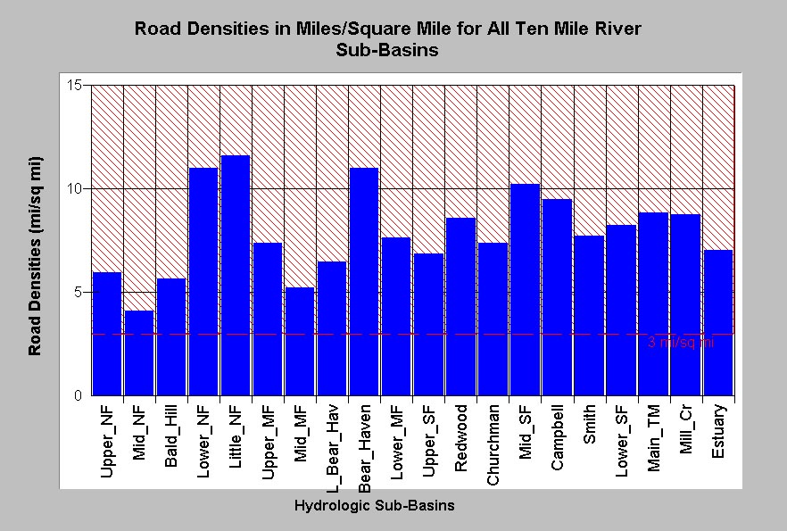
This chart shows road densities in miles per square mile, estimated by Matthews (2000), for all Ten Mile River sub-basins. According to the National Marine Fisheries Service (1996) properly functioning conditions require road densities less 3 miles per square mile. Road densities exceed this limit in all sub-basins. The lowest road densities are found in the Middle North Fork basin (4.11 mi/sq mi) and the highest are in the Little North Fork (11.41 mi/sq mi). |
|
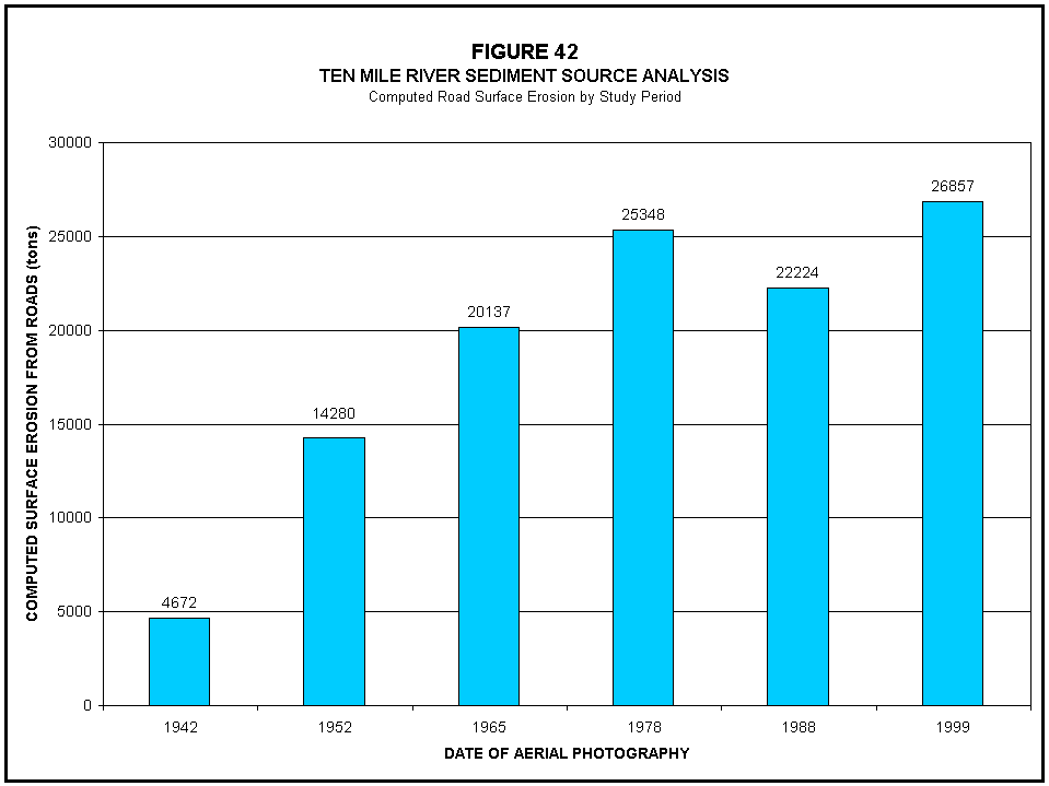
The chart at left, Figure 42 from Matthews (2000), shows the amount of surface erosion from roads by period. In the most recent period, the sediment yield from roads coincides with extensive road construction in the South Fork sub basin. |
![]()
References
Matthews, Graham and Associates. 2000a. Sediment source analysis and preliminary sediment budget for the Ten Mile River, Mendocino County, CA. Prepared for Tetra Tech, Inc. VOLUME 1: Text, Tables, and Figures. Fairfax, VA. 143 pp.
Matthews, Graham and Associates. 2000b. Sediment source analysis and preliminary sediment budget for the Ten Mile River, Mendocino County, CA. Prepared for Tetra Tech, Inc. VOLUME 2: Appendices. Fairfax, VA. 59 pp.
![]()
| www.krisweb.com |