
|

|
| Background | Hypotheses | Bibliography | Maps | Home |
|
|
|
| Background | Hypotheses | Bibliography | Maps | Home |
KRIS Web Background Pages: Riparian Areas
![]()
The KRIS Big River database contains canopy cover information from habitat typing surveys provided by the Hawthorne Timber Company (HTC) and the California Department of Fish and Game. This information can be used to gauge stream health (see background page for Habitat Typing). Canopy is measured with a densiometer. One problem with canopy information is that is does not indicate riparian over-story conditions, which effect microclimate and large wood recruitment potential.
The KRIS Big River Map project contains forest stand data from the U.S. Forest Service Pacific Southwest Region Remote Sensing Lab (see Vegetation Information in KRIS ) and U.S. Geologic Survey (USGS) digital orthophotos for a delimited area, which both can be used to assess riparian health. The USFS vegetation can be filtered to show only a buffer of 90 meters (297 feet) immediately adjacent to both sides of the stream and shows tree size at the one hectare scale. The 90 meter area was chosen to represent a zone of influence that contributes large wood and helps control microclimate over the stream.
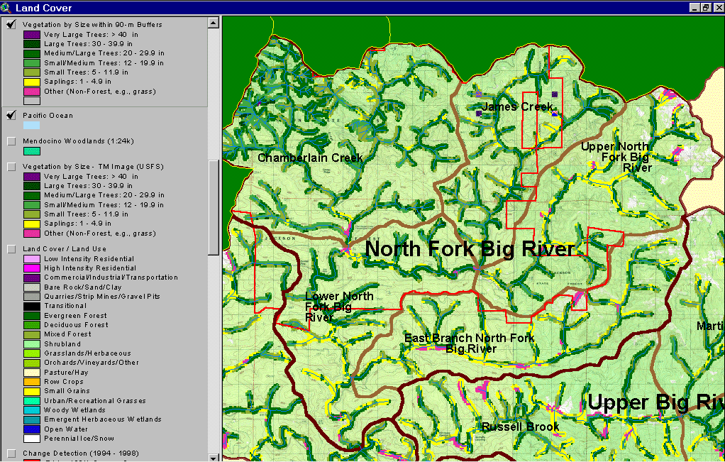 |
This image, from the KRIS Big River Map project, shows USFS vegetation and stand types for 90 meters surrounding the North Fork Big River and its tributaries. The riparian is comprised of Large Trees (30-39.9"), Medium Large Trees (20-29.9") or Small/Medium Trees (12-19.9") on most of Jackson Demonstration State Forest. The high prevalence of Saplings (< 5" diameter) on the East Brach of the NF and Upper North Fork represents substantial, recent riparian timber harvests. Areas that are natural grasslands, due to bedrock geology, are shown in white on the USGS Topo backdrop and are naturally in Non-Forest conditions. Derived from a 1994 Landsat image (see USFS VegType Topics for more information). |
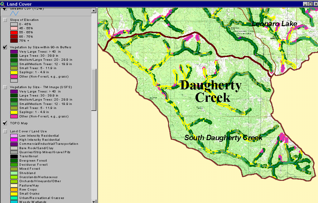 |
This KRIS Big River map image shows USFS vegetation and stand types for the riparian zone (90 meter buffer) of Daugherty Creek, derived from a 1994 Landsat image. Non-Forest and Saplings in the riparian zone are mostly associated with recent timber harvest. The scale of accuracy for stands is one hectare. Non-forest in the upper portions of tributaries to the east may be natural grasslands, which show as white areas on the USGS Topo. |
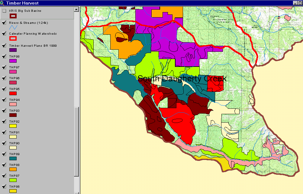 |
The image above, from the KRIS Big River Map project, shows timber harvests as mapped by the California Department of Forestry by year from 1986 to 1999. Over 50% of the basin was logged in this period. Extensive areas adjacent to the mainstem Daugherty Creek show a linkage between recent logging and the poor riparian conditions along this stream. |
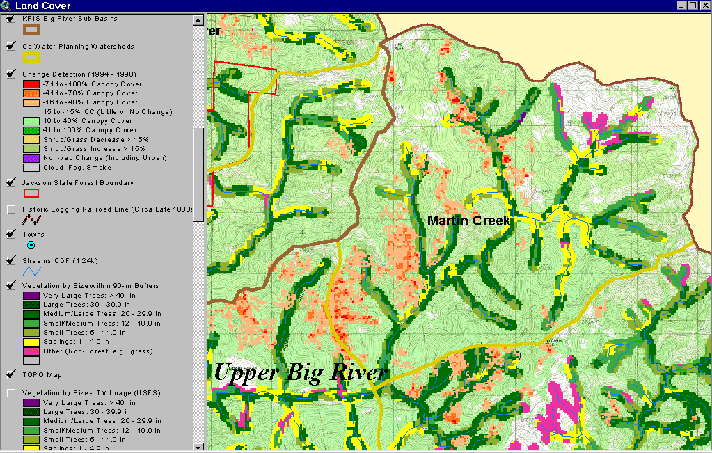 |
The image at left shows the riparian area of Martin Creek, in the Upper Big River drainage, using the 1994 Landsat classification by the USFS Spatial Analysis Lab in Sacramento. It also shows change scene detection derived by comparing 1994 and 1998 Landsat images from the California Department of Forestry (Fisher, 2001). The latter shows substantial changes in riparian conditions of Martin Creek between 1994 and 1998 associated with timber harvest. See background page for Vegetation Types for more information on change scene detection. |
![]()
References
Georgia-Pacific Co. 1996. Habitat typing inventory reports: Ten Mile River Watershed. Surveys conducted during 1994/95. Unpublished file memo. Fort Bragg, CA. 103 pp.
Keithley, C. 1999. Evaluating Stream and Watershed Conditions in Northern California. Prepared for the California Department of Forestry, Fire and Resource Assessment Program. Sacramento, CA. 17 pp.
Schwind, B. 1999. USFS Thematic Mapper Landsat Vegetation Coverage Background Information. USDA Forest Service. Pacific Southwest Region Remote Sensing Lab. Sacramento, CA.
Warbington, R., B. Schwind, C. Curlis and S. Daniel. 1998. Creating a Consistent and Standardized Vegetation Database for Northwest Forest Plan Monitoring in California. USDA Forest Service. Pacific Southwest Region Remote Sensing Lab. Sacramento, CA.
![]()
| www.krisweb.com |