
| Area | Lagunitas Creek |
| Topic | Flow: Lagunitas Creek at SPT State Park, Season 5/1-6/15, Medians |
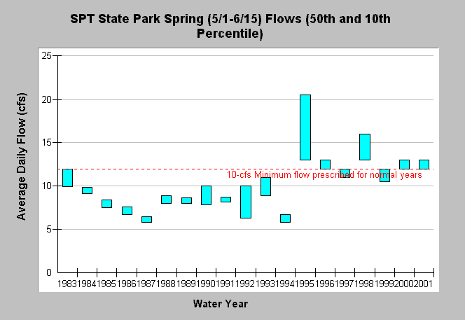
| Caption: This chart shows the median daily average flow (top of bar) and 10th percentile (bottom of bar) at the lower Lagunitas Creek gage (USGS, Samuel P. Taylor State Park) for the spring period of May 1 through June 15 water years 1983-2001. This spring period has been identified as important for rearing and emigration of coho salmon and steelhead trout in Lagunitas Creek. The State Water Resources Control Board prescribed in 1995 that minimum flows of 12-cfs in normal years and minimum flows of 10-cfs in dry years should be maintained during this entire period to avoid limiting fish production. See Info Links for more information. | |
 |
To learn more about this topic click Info Links .
To view additional information (data source, aquisition date etc.) about this page, click Metadata .
To view the table with the chart's data, click Chart Table web page.
To download the table with the chart's data, click flow_lag_sptsp_spring_box.db (size 4,096 bytes) .
To view the table with the chart's source data, click Source Table web page.
To download the table with the chart's source data, click flow_lag_doy.db (size 673,792 bytes)
| www.krisweb.com |