| Area | Middle Trinity |
| Topic | Sediment: Upper Middle Trinity - Sediment Transport 1981-2001 |
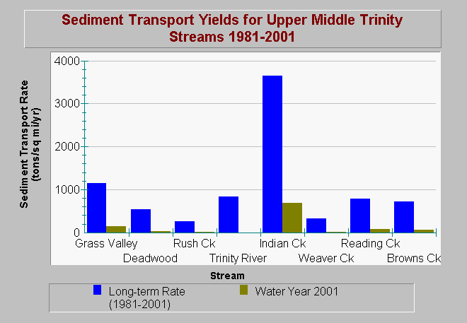
| Caption: This chart compares long-term (1981-2000) sediment transport rates with rates from the 2001 water year. Note that the WY2001 was an extremely dry year; however, the data shows that Grass Valley and Indian Creeks are the main sediment sources downstream of Lewiston Dam, and due to the level of disturbance, provide significant loads even in critically dry years. Sediment contributions from these streams exceed the transport capacity of the mainstem Trinity. This type of loading will result in continuous growth of sediment deposits in the mainstem. Data are from Graham Matthews and Associates Trinity River Sediment Source Analysis (2001). See Info Links for more information. | |
 |
To learn more about this topic click Info Links .
To view additional information (data source, aquisition date etc.) about this page, click Metadata .
To view the table with the chart's data, click Chart Table web page.
To download the table with the chart's data, click sed_totaltransportstats_up_mid_trinity_gma_1981_2001.dbf (size 650 bytes) .
To view the table with the chart's source data, click Source Table web page.
To download the table with the chart's source data, click sed_totaltransport_up_mid_trinity_gma_1981_2000.dbf (size 2,707 bytes)
| www.krisweb.com |
