
| Area | S.F. Trinity |
| Topic | Stream Channel: Cross-Section SF @ Salyer Changes 1955-2000 |
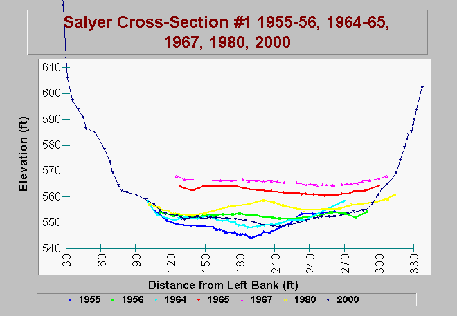
| Caption: This chart shows data from Salyer cross section 1 (near USGS gage 11529000). These data were collected for the Six Rivers National Forest Long Term Trend Monitoring Project for the South Fork Trinity River Watershed. The data record extends from 1955 to 2000. Some historic cross section data associated with this site show 20 feet of aggradation after the 1964 flood and subsequent degradation to near 1955 levels. Whether these changes represent overall watershed response or just local hydraulics is unclear. It is possible that the lower mainstem has already flushed through sediments from the 1964 flood. This reach has a lower gradient (0.2 percent) and contains more stored sediment than any other reach below Hyampom Valley and should reflect changes in the entire watershed. Thus, it is the most sensitive reach of mainstem channel in the lower watershed and is also used by nearly all anadromous fish in one way or another. It is an important place to monitor and more comprehensive monitoring of the Salyer Reach may reveal if the changes at the USGS gage are anomalous or actually represent lower mainstem conditions. The channel in the Salyer Reach is quite confined, often by bedrock walls. Average bankfull width is 290 feet. Streamside landslides are common in this reach, including several large features. Although landslides may cause local data anomalies, large active landslides are common throughout the lower South Fork Trinity River. See Info Links for more information. | |
 |
To learn more about this topic click Info Links .
To view additional information (data source, aquisition date etc.) about this page, click Metadata .
To view the table with the chart's data, click Chart Table web page.
To download the table with the chart's data, click sf_srnf_salyer_xs1.dbf (size 10,916 bytes) .
| www.krisweb.com |