Bibliography Background About KRIS
Flow and Climate Data in KRIS Kootenai
Streamflow data in the pilot KRIS Kootenai project come from U.S. Geological Survey (USGS) and the Water Survey of Canada (WSC). Climate data are from the National Climatic Data Center and are compiled and maintained by the Western Regional Climate Center. The KRIS database when operated from your hard drive, allows full review of all flow records by water year, a function which cannot be duplicated on the KRIS website. The ability to quarry all flow and climate data is a powerful watershed analysis tool. Below are examples of various flow and climate charts found in the pilot KRIS Kootenai project.
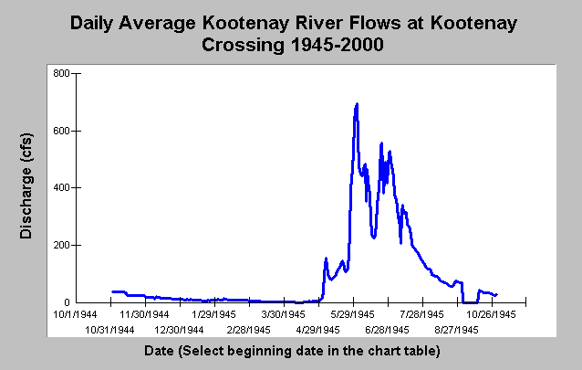 This chart shows the first year of flow records available for the Kootenai River at Libby Montana, which is 1945. The USGS and WSC publish daily average discharge, monthly average discharge, and annual peak discharge records from streamflow gages throughout the United States and Canada. Gage records are reported by water year. A water year begins on October 1 of the prior calendar year and extends to September 30 of the following year. For example, the 1945 water year in the chart at left started on October 1, 1944 and extends to September 30, 1945. All water years could be quarried in the KRIS database. View web pages showing flow data in KRIS.
 This chart from the KRIS Kootenai project Kootenai Lake sub-basin shows a summary of annual peak discharge measured at Leonia, ID between 1928 and 2001. Annual peak flows occurred between April and June prior to the construction of the Libby dam in 1992. After dam construction, annual peak flows decrease in magnitude and occur during late fall and in winter months. Flow mitigation since1991 attempts to re-establish peak flow magnitudes and re-time annual peaks to the summer months (Paragamian, et al, 2001). Based on data from USGS gage #12305000.
 This chart from the KRIS Kootenai project Kootenai Lake sub-basin shows a summary of annual peak discharge measured at Leonia, ID between 1928 and 2001. Annual peak flows occurred between April and June prior to the construction of the Libby dam in 1992. After dam construction, annual peak flows decrease in magnitude and occur during late fall and in winter months. Flow mitigation since1991 attempts to re-establish peak flow magnitudes and re-time annual peaks to the summer months (Paragamian, et al, 2001). Based on data from USGS gage #12305000.
Climate data for the Kootenai River Watershed includes monthly average air temperature, monthly average snowfall, and monthly average and annual precipitation quantities and extremes. Climate data are from the National Climatic Data Center and are compiled and maintained by the Western Regional Climate Center. The chart at left show monthly average air temperatures for Libby, Montana. View web pages showing climate data in KRIS.
Reference
Paragamian, V., J.P. Walters, C.C. Downs. 2001. Kootenai River fisheries investigations: Rainbow and bull trout recruitment annual progress report, January 1, 1999- December 31, 1999. Idaho Department of Fish and Game. Report to Bonneville Power Administration (BPA). BPA Report DOE/BP-00004691-1. Portland, OR. 53pp. [660k]