Bibliography Background About KRIS
Hypothesis #3: A reduced supply of large wood has contributed to the loss of pool habitat and the decline of coho salmon in the Navarro River basin.
Large wood is an extremely important element in creating and maintaining fish habitat diversity, especially in coastal streams (see Big Wood Background page). Large wood can buffer impacts from excess sediment supply (Kelley et al., 1995), and may also help keep streams cool by forcing more flow into shallow ground water (Poole and Berman, 2000). Reeves et al. (1989) found that juvenile coho salmon preferred pools formed by large wood. Large wood in streams has been shown to increase pool frequency and coho salmon production (Cedarholm et al., 1997). Keithley (1999) used a cut off size of 24 inches basal diameter or larger to represent mid-late seral conifers which could function properly as large woody debris, if recruited to a stream.
Logging is recognized as a factor in decreasing wood supply to streams. Reeves et al. (1993) stated that streams on the Oregon coast with less than 25% of their watershed area previously logged "had significantly more pieces of wood per 100 meters, 2 to 12 times more, than streams in high-harvest basins. Streams in low-harvest basins also had 10-47% more pools per 100 meter than did streams in high-harvest basins". According to Montgomery et al. (1995), forced pool-riffle channels where large woody debris is available exhibit pool spacing between 0.2 to 3 channel widths. Murphy et al. (1986) found that undisturbed forested streams had 39-67% pool frequency by length.
Reeves et al. (1993) also noted a loss of Pacific salmon species diversity in streams flowing from high harvest basins and traced it to aquatic habitat simplification. Entrix et al. (1998) also asserted that: "removal of LWD typically results in loss of pool habitat and complexity, lower fish numbers, smaller average size, and a reduced total biomass" based on work by Tschaplinski and Hartman (1986). Stillwater Sciences (1997) postulated that extraction of large wood had a major negative effect on coho salmon in Mendocino County. Ligon et al. (1999) recommended more restrictive timber harvest in California riparian zones to help recover Pacific salmon species.
From the Navarro Basin
Logging in riparian zones was common in the post World War II era and roads were often constructed next to streams (Figure 1). This had a huge effect on long term prospects for supply of large wood to the Navarro River and its tributaries. The log jams caused by cull logs and slash stimulated a wave of large wood removal from Mendocino coastal streams meant to improve fish passage (Holman and Evans, 1964). Sixteen California Department of Fish and Game memos (1973; 1983; 1984a-b; 1985a-f; 1988a-b; 1991) documented large wood removal projects in numerous Navarro River tributaries.
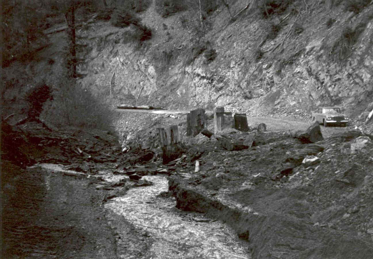 Figure 1. This photo, from 1963, shows the stream channel of Ham Canyon Creek, a tributary to Rancheria Creek. Note the large diameter stumps between the creek and the road at right, indicating logging immediately adjacent to the stream. This is typical of the destructive practices of the era, which still have profound lingering effects today. Photo taken by W.T. Bakker and collected from California Department of Fish and Game, Region 3, Yountville, CA.
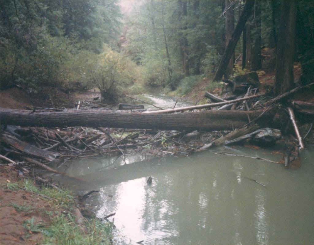
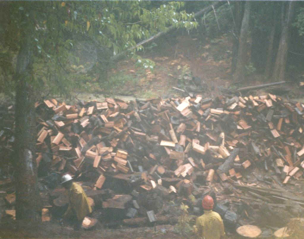 Figures 2 and 3. The photo at left shows a small debris jam and a spanning log which was deemed a potential barrier. The photo at right shows the spanning log and other wood from the channel chopped into fire wood sized pieces to be removed from the flood plain or burned. Similar projects were completed from the 1960's to about 1990 in Navarro sub-basins such as Indian Creek, Anderson Creek, Elk Creek, and North Fork Navarro River.
This practice was extremely destructive to habitat diversity of Mendocino County streams (Stillwater Sciences, 1997). Large wood is now being added to streams as part of restoration (Entrix et al., 1998).
Photos are from the archives of E-Center/Mendocino Fisheries Program of Ukiah.
The Navarro Watershed Restoration Plan (Entrix et al., 1998) found that pools were much less frequent than expected when compared to the 0.2-3 pools per channel width references from Montgomery et al. (1995). Pool spacing in surveyed Navarro River reaches was as infrequent as every 7.7 channel widths (Figure 3). Entrix et al. (1998) found that pools comprised from 10 to 43 percent of the habitat types, and were generally less than expected for forested streams (Montgomery et al. 1995). They also noted that there were few pools formed by large woody debris (LWD) in most of the surveyed reaches (Figure 3), except in John Smith Creek where LWD was added by restoration projects in the survey reach. The report correlated the low quantity of pool habitat to the lack of LWD recruitment, attributed to intensive logging in the 1950s and 1960s, large wood removal projects, and continued logging of large trees in the riparian zone.
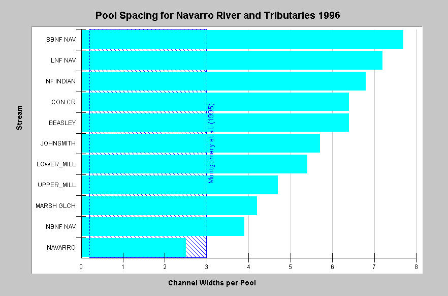 Figure 3. Pool spacing data collected as part of the Navarro River Watershed Restoration Plan (Entrix et al., 1998) show values ranging from one pool for every 2.5 widths (Mainstem Navarro River) to 7.7 widths (SB North Fork Navarro River). The reference of one pool for every three channel widths is from Montgomery et al. (1995). Only the seventh order mainstem Navarro meets this standard. Entrix (1998) field crews noted a lack of LWD in most surveyed reaches.
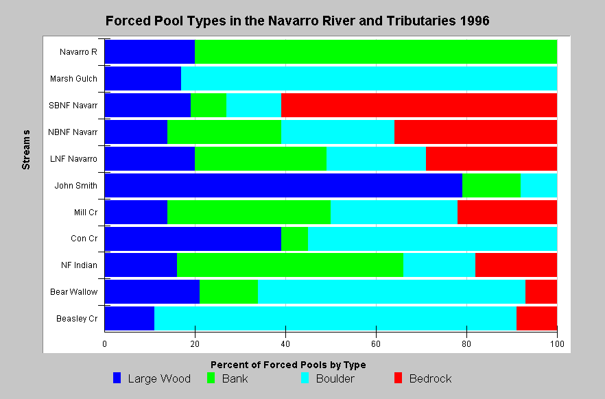 Figure 4. This chart shows that most of the stream reaches surveyed in the Navarro basin have fewer than 20% of their pools formed by large wood. The mainstem Navarro River is large enough to transport any large wood that might be deposited, but many of the lower order tributaries are too narrow for transport of large logs. Streams in the chart are sorted by Strahler order, with larger streams at the top. Values less than 20% in tributaries indicate a very low supply of large wood. Data provided by Entrix et al., 1998.
Riparian conditions can be assessed in part using canopy closure from habitat typing surveys (CDFG, 1998). Canopy closure is the measurement of direct shade provided by different tree types, with categories of coniferous, deciduous or open. North Fork Navarro River habitat typing surveys show streams with canopies mostly of deciduous trees, with several having up to 20% of the reach with no shade at all (Figure 5). This is indicative of prior logging in the riparian zone which has released alder and other hardwoods next to the stream as part of succession. Even if shade is provided by conifers, there is no indication that they are of sufficient diameter to provide long lasting large wood in the stream.
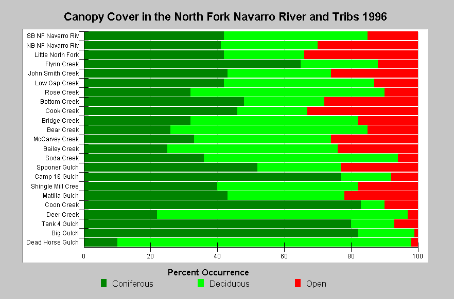 Figure 5. This chart of canopy closure from CDFG's 1996 habitat typing surveys of the North Fork Navarro River sub-basin shows that coniferous trees comprised 50% shade in only 6 of the 23 streams surveyed (26%). This indicates low potential recruitment of conifers to streams. Streams in the chart are sorted by Strahler order, with larger streams at the top. Data from the California Department of Fish and Game.
According to the California Department of Forestry records, timber harvest has remained active in the Navarro River basin since 1990, including some harvest in riparian zones in streams like Rays Gulch (Figure 6). While these stream side areas may not be clearcut, as in prior eras, removal of some large diameter trees has continued, which further reduces the potential large wood supply to streams.
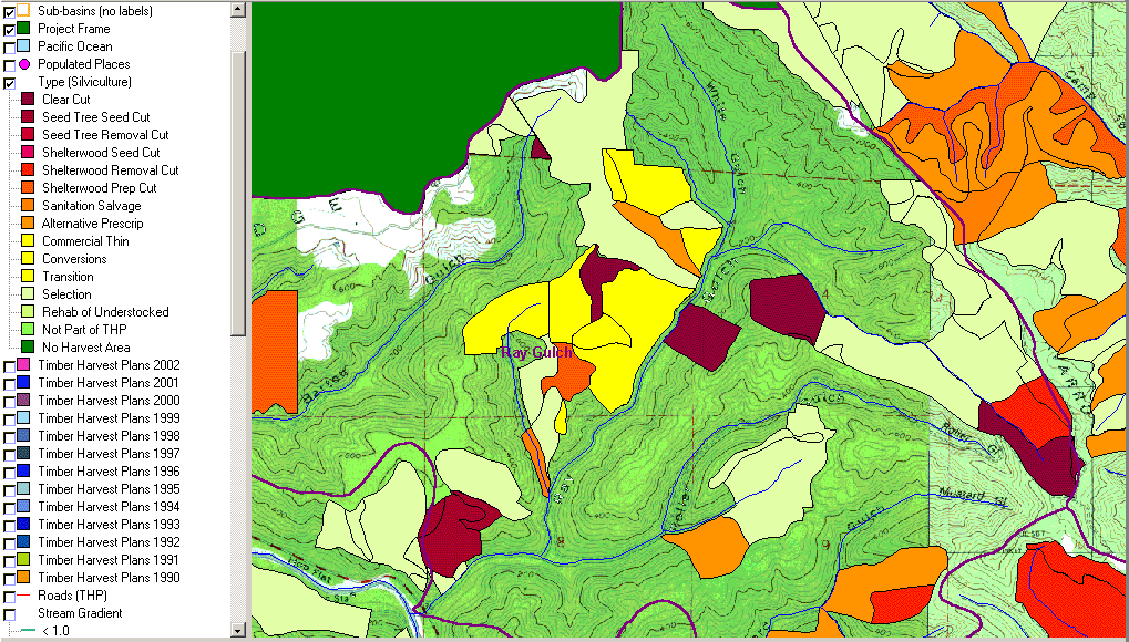 Figure 6. This map from the KRIS Navarro database shows timber harvests from 1990 to 2002 in Rays Gulch in the western portion of the Navarro River basin. Note that timber harvests were filed for most of the riparian zones, although most harvests were not clearcuts. Some of the recent harvests are also in steep, inner gorge settings which are the source of natural recruitment for large wood to streams. Data from CDF, Santa Rosa, CA.
The U.S. Forest Service Spatial Analysis Lab in Sacramento has provided Landsat imagery of vegetation for the Navarro River basin and all of California which can be used to characterize forest stand conditions (Warbington et al., 1998). This coverage is based on the 1994 Landsat imagery and KRIS projects apply a 90 meter buffer to U.S. Geologic Survey 1:24000 stream maps to represent a riparian zone. Stand conditions are calculated on a hectare basis and there may be some individual large diameter trees which do not show up. Average tree size can be calculated for Calwater Planning Watersheds and such summary statistics are shown for just the riparian zone of Rays Gulch (Figure 7).
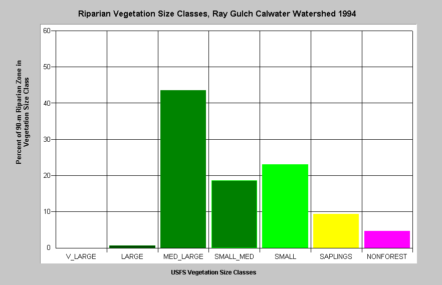 Figure 7. This chart shows the breakdown of size classes in the 90 meter riparian zone in the Rays Gulch Calwater Planning Watershed. Almost 60% of the riparian zone is in trees less than 20 inches in diameter. Vegetation is classified according to diameter at breast height (DBH): Giant = >50" DBH, V Large = 40-50" DBH, Large = 30-39.9" DBH, Medium/Large = 20-29.9" DBH, Small/Medium = 12-19.9" DBH, Small = 5-11.9" DBH, Non-Forest = No trees, shrubs, grass, bare soil. Data from the USFS Spatial Analysis Lab in Sacramento.
Fischer (2002) provided data discerning changes between 1994 and 1998 Landsat imagery, known as change scene detection, which shows reduction in canopy or areas of rapid forest growth. Figure 8 shows the riparian tree size of the 90 meter buffer with change scene detection in map form for Rays Gulch. See the Vegetation Types Background page for more information on use of remote sensing vegetation imagery.
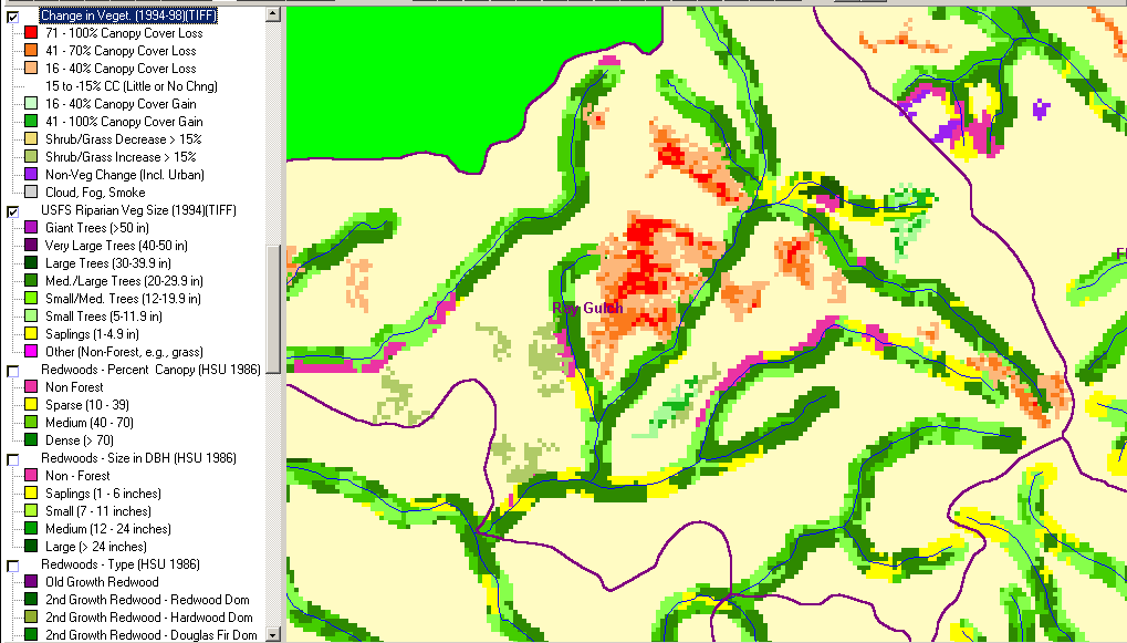 Figure 8. This map shows the size classes of trees within a 90 meter buffer of Rays Gulch according to 1994 Landsat imagery and change scene detection from 1994 to 1998. The small tree diameters and recent logging in the riparian zone indicate a depleted supply of large wood for Rays Gulch, which can be expected to last for several decades. Data from USFS Spatial Analysis Lab and California Department of Forestry FRAP, Sacramento, CA.
The KRIS Navarro project also provides access to U.S. Geologic Survey orthophotos, which correspond to USGS topographic map quadrangles and can be used in the KRIS Map Viewer. A zoom in on Rays Gulch (Figure 9) gives visual indications of riparian conditions.
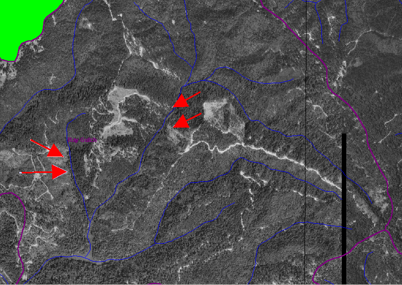 Figure 9. This image is from the orthophoto covering Rays Gulch. The red arrows point to riparian areas where recent timber harvest has reduced potential large wood recruitment to Rays Gulch. The two red arrows at left appear in a cut that must have occurred before 1990 because it does not show up in Figure 6.
Topics Supporting the Hypotheses
The following is a list of Topics in KRIS Navarro where you can see data in its context, Metadata and associated Info Links. The large-case letters in parentheses indicate KRIS sub-basins.
(RC) Tour: 2. Historic Photos, Ham Canyon Cr Log Jam Removal 1963
(BW) Habitat: Percentage of Forced Pools by Type 1996
(BW) Tour: Navarro River Large Wood Barrier Removal Project
(BW) Habitat: Pool Spacing in Navarro River and Tributaries 1996
(NF) Habitat: Canopy by Type North Fork Navarro Sub-basin 1996
(BW) MapMaster: 4 Timber Harvest, Navarro Project Area
(BW) MapMaster: 1 Land Cover, Navarro Project Area
(BW) MapMaster: 3 Digital Orthophotos (DOQs), Navarro Project Area
Alternate Hypothesis
Large wood supply is not an appreciable factor in the decline of coho salmon abundance.
This alternative hypothesis points to the other factors which may reduce coho salmon abundance. Support for this alternative hypothesis could point to sedimentation as the dominant limiting factor. High water temperature could also be a competing mechanism for coho decline. Ultimately, support for this alternative hypothesis must demonstrate that coho salmon can persist in abundance in a variety of natural streams without large wood.
Monitoring Trends to Test the Hypotheses
Studies could be conducted wherein large wood is added to streams with low numbers of coho to see if juvenile carrying capacity increases. Collecting additional data on coho salmon populations and aquatic habitat could answer questions about the relationship between large wood, pool habitat, and coho salmon persistence or decline.
References
California Department of Fish and Game (CDFG). 1973. Memorandum to P. Baker, (CDFG), from Warden K.L. Bain (CDFG), regarding stream clearance projects, North Fork Navarro . Unpublished CDFG file memo. Yountville, CA. 1 p. [16kb]**
California Department of Fish and Game (CDFG). 1983. Little North Fork Navarro River (Navarro River tributary) fish habitat improvement completion form . CDFG unpublished file memo. Yountville, CA . 2 pp. [ 127kb]**
California Department of Fish and Game (CDFG). 1984a. Indian Creek (Navarro River tributary) stream barrier removal final report . CDFG unpublished file memo. Yountville, CA. 1 p. [6k]**
California Department of Fish and Game (CDFG). 1984b. Indian Creek (Navarro River tributary) stream improvement completion form . CDFG unpublished file memo. Yountville, CA. 1 p. [4kb]**
California Department of Fish and Game (CDFG). 1985a. Cook Creek (North Fork Navarro tributary) fish habitat improvement completion form, August 1985 . CDFG unpublished file memo . Yountville, CA . 2 pp. [450k]**
California Department of Fish and Game (CDFG). 1985b. Little North Fork Navarro (North Fork Navarro tributary) fish habitat improvement completion form, March 1985 . CDFG unpublished file memo . Yountville, CA. 1 p. [4kb]**
California Department of Fish and Game (CDFG). 1985c. South Branch North Fork Navarro River fish habitat improvement completion form, with summary report, March 1985 . CDFG unpublished file memo . Yountville, CA. 3 pp. [12kb]**
California Department of Fish and Game (CDFG). 1987a. Horse Creek (Rancheria Creek tributary) stream improvement completion form . CDFG unpublished file memo. Yountville, CA. 3 pp. [137kb]**
California Department of Fish and Game (CDFG). 1987b. Indian Creek (Navarro River tributary) stream improvement completion form (barrier removal) . CDFG unpublished file memo by unknown. Yountville, CA. 2 pp. [485kb]**
California Department of Fish and Game (CDFG). 1987c. Little North Fork Navarro River (North Fork Navarro River tributary) stream improvement completion form (barrier removal) . CDFG unpublished file memo by unknown . Yountville, CA. 2 pp. [29kb]**
California Department of Fish and Game (CDFG). 1987d. North Fork Indian Creek (Indian Creek tributary) fish habitat improvement completion form (barrier removal). CDFG unpublished file memo . Yountville, CA. 3 pp. [120kb] **
California Department of Fish and Game (CDFG). 1987e. North Fork Navarro River (Navarro River tributary) fish habitat improvement completion form . CDFG unpublished file memo. Yountville, CA. 2 pp. [490kb]**
California Department of Fish and Game (CDFG). 1987f. South Branch North Fork Navarro River (Navarro River tributary) fish habitat improvement completion form . CDFG unpublished file memo. Yountville, CA. 2 pp. [487kb]**
California Department of Fish and Game (CDFG). 1988a. Letter to Mr. J. Santana regarding fish blockage on Con Creek, dated 3 February 1988 . CDFG unpublished file memo by B. Hunter. Yountville, CA. 1 p. [7kb]**
California Department of Fish and Game (CDFG). 1988b. North Fork Navarro (Pacific Ocean tributary) fish habitat improvement completion form. CDFG unpublished memo. Yountville, CA. 1 p. [4kb]**
California Department of Fish and Game (CDFG). 1991. South Branch North Fork Navarro (North Fork Navarro River tributary) fish habitat improvement completion form . CDFG unpublished file memo. Yountville, CA. 1 p. [4kb]**
Cedarholm, C.J., R.E. Bilby, P.A. Bisson, T.W. Bumstead, B.R. Fransen, W.J. Scarlett and J.W. Ward. 1997. Response of Juvenile Coho Salmon and Steelhead to Placement of Large Woody Debris in a Coastal Washington Stream. North American Journal of Fisheries Management. 17:947-963.
Entrix Inc., Pacific Watershed Associates, Circuit Rider Productions Inc., Navarro Watershed Community Advisory Group, and D.T. Sicular. 1998. Navarro Watershed Restoration Plan. Prepared for Mendocino County Water Agency, California State Coastal Conservancy, and Anderson Valley Land Trust Incorporated. Ukiah. 545 pp. [5Mb]**
Fischer. Change Scene Detection 1994-1998. CDF FRAP, USFS Spatial Analysis Lab, Sacramento, CA.
Kelly, E.A., A. MacDonald, T. Tally and N.J. Merrit. 1995. Effects of Large Organic Debris on Channel Morphology and Sediment Storage in Selected Tributaries of Redwood Creek, Northwestern, California. U.S. Geologic Survey Professional Paper 1454-P, Menlo Park, CA. 29 p.
Keithley, C. 1999. Evaluating stream and watershed conditions in Northern California. Prepared for the California Department of Forestry, Fire and Resource Assessment Program. Sacramento, CA . 17 pp. [1.06Mb]**
Ligon, F., A. Rich, G. Rynearson, D. Thornburgh, and W. Trush. 1999. Report of the Scientific Review Panel on California Forest Practice Rules and Salmonid Habitat. Prepared for the Resources Agency of California and the National Marine Fisheries Service. Sacramento, CA. 181 pp.
Montgomery, D. R., J. M. Buffington, R. D. Smith, K. M. Schmidt, and G. Pess. 1995. Pool spacing in forest channels. Water Resources Research, Vol. 31, No. 4, Pgs. 1097-1105, April 1995.
Murphy, M.L., J. Heifitz, S.W. Johnson, K.V. Koski, and J.F. Thedinga. 1986. Effects of clear-cut logging with or without buffer strips on juvenile salmonids. In Alaskan streams. Canadian Journal of Fisheries and Aquatic Sciences 43:1521-1533.
Poole, G.C., and C.H. Berman. 2000. Pathways of human influence on water temperature dynamics in stream channels. Environmental Management. 20 pp.
Reeves, G. H., F. H. Everest, and T. E. Nickleson. 1989. Identification of physical habitats limiting the production of coho salmon in Western Oregon and Washington. General technical report PNW-GTR-245. USDA Forest Service, Pacific Northwest Research Station . Portland, OR. 25 pp. [396kb]**
Reeves, G. H., F. H. Everest, and J. R. Sedell. 1993. Diversity of juvenile anadromous salmonid assemblages in coastal Oregon basins with different levels of timber harvest . Transactions of the American Fisheries Society. 122(3): 309-317. [119kb]**
Stillwater Sciences. 1997. A review of coho salmon life history to assess potentially limiting factors and the implications of historical removal of large woody debris in coastal Mendocino County. Prepared by Stillwater Sciences, Berkeley CA for Louisiana-Pacific Corporation, Wildlife and Fisheries Science Group, Forest Resources & Fiber Procurement Division. May 1997. 55 pp.
Tschaplinski, P.J. and G.F. Hartman. 1986. Winter distribution of juvenile coho salmon (Oncorhynchus kisutch) before and after logging in Carnation Creek, British Columbia, and some implications for over-winter survival, Can. Journal Fish. Aquatic Science 40:452-461.
Warbington, R., B. Schwind, C. Curlis and S. Daniel. 1998. Creating a Consistent and Standardized Vegetation Database for Northwest Forest Plan Monitoring in California. USDA Forest Service. Pacific Southwest Region Remote Sensing Lab. Sacramento, CA.