Bibliography Background About KRIS
Hypothesis #4: High sediment yield in Navarro River basin has caused aquatic habitat changes which limit coho salmon and steelhead production.
Fine sediment and sand, when present in excess, are known to damage salmon and steelhead redds, and to cause the decreased survival of eggs and successful emergence of fry (McNeil and Ahnell, 1964; McHenry et al., 1994). The permeability of stream gravels is an index that can be used to understand spawning gravel quality and potential salmonid egg and alevin survival (Barnard and McBain, 1996; Tagart, 1976; McCuddin, 1977). Reeves et al. (1989) recognized that coho salmon juveniles preferred pools and Brown et al. (1994) described optimal habitat for coho rearing as greater than a meter deep. Reeves (1988) found that juvenile steelhead yearlings also required pools greater than three feet in depth for successful rearing. Knopp (1993) found that pools in watersheds with intensive management had a higher volume of sediment than those in watersheds not actively managed.
Sigler et al. (1984) found that steelhead juveniles ceased growth when turbidity rose to greater than 25 nephlometric turbidity units (ntu). Sediment contributions may decrease bed particle size (Dietrich et al., 1989), which in turn can lead to bedload mobility and increased mortality of salmonid eggs and alevin (Nawa et al., 1990). Knopp (1993) noted that the mean particle size (D50) of the stream bed in watersheds with a high disturbance regime was small (<37 mm). Cedarholm et al. (1981) recognized roads as a major sediment source impacting salmonids and found that fine sediment damaging to redds occurs at road densities over 1.8 miles of road per square mile of watershed. The National Marine Fisheries Service (1996) recommended that there be no more than 2.5 mi./sq. mi. of roads in a watershed to maintain "properly functioning condition" for Pacific salmon. (See Sediment Background page for more information).
Support for the Hypothesis from the Navarro
Entrix et al. (1998) recognized that the productivity of fisheries in the Navarro River was compromised by sediment, noting specifically low pool frequency and high fine sediment in spawning gravels. Early logging on the Navarro River watershed may have occurred in restricted areas, but those logged areas are likely to have caused substantial sediment yield (Figure 1).
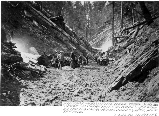 Figure 1. This picture shows an oxen team hauling logs up a stream course in 1890. Note the channel choked with fine sediment. Photo courtesy of the Held-Poage Historic House, Robert Lee collection L-08240, Nichols.
A 1955 California Department of Fish and Game memo (CDFG, 1955) documented severe damage to the Navarro River and its tributaries from post World War II logging and road building:
"The Masonite Corporation has built a road along areas of both the North and South branches of the North Fork, and on some of their tributaries. This road system has, in many cases, restricted the channels of the streams. Shoulders of this road periodically sluff off into the stream during heavy rains, thereby contributing large amounts of sand and silt which is deposited along the bottom of the stream. Much of this silt is carried along in the water and undoubtedly contributes to the decreasing depth of the lagoon."
Other CDFG (1954; 1962a; 1962b) memos document similar damage to streams from logging and road building. Figure 2 shows the Masonite Road and illustrates how massive quantities of soil were washed into the North Fork Navarro River from slides triggered by road failures during large storm events that followed construction in 1949.
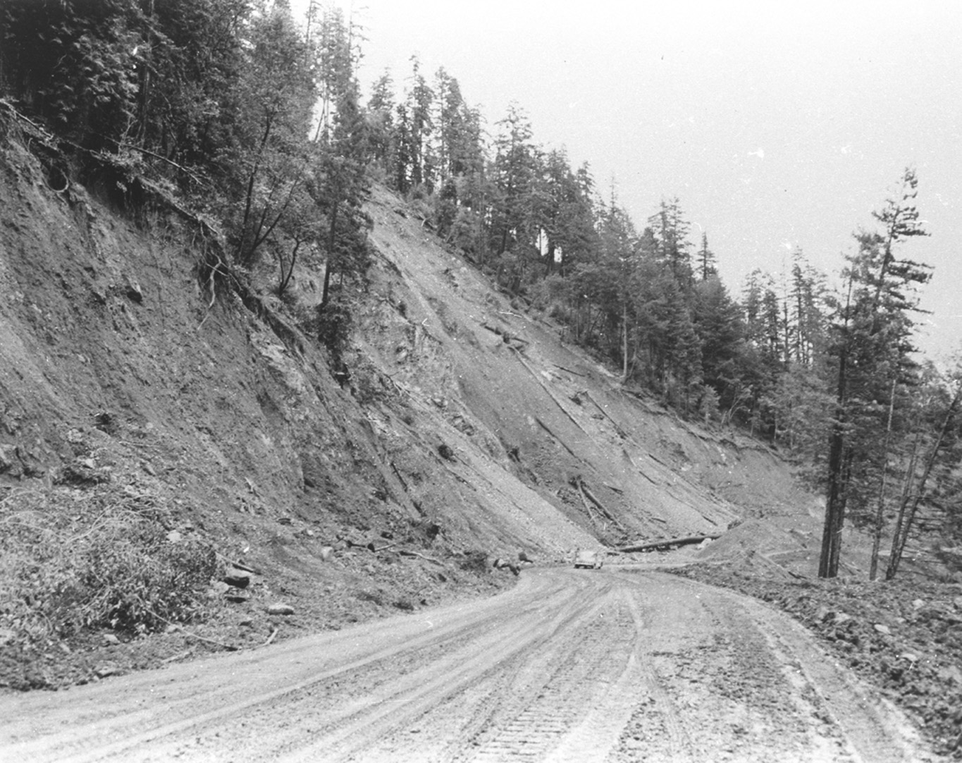 Figure 2. This picture shows a massive slide on steep, erodible slopes in the North Fork Navarro River basin on the Masonite Road, which ran from Ukiah to Highway 128 near the town of Navarro. The note associated with this image says "First large slide east of Navarro terminus".
Photo provided courtesy of the Mendocino County Museum in Willits, CA. Further use requires their permission. Donated by Roger Krueger and Louisiana Pacific Corp.
The Navarro River has been recognized as sediment impaired by the U.S. Environmental Protection Agency (2000) particularly because of impacts on coho salmon and steelhead trout, which are considered "beneficial uses" under the Clean Water Act. "Overall, these conditions indicate that excessive amounts of coarse and fine sediment are causing decreased habitat quality for salmonids" (U.S. EPA, 2000). "Human-caused sources account for about 40% of the total sediment yield of the Navarro watershed. Road-related sources dominate other anthropogenic sources, reflecting the dominant land uses in the watershed, specifically timber production and ranching, which use a vast network of roads. Vineyards, which occupy only about 2 percent of the watershed, have the potential to cause locally significant deleterious impacts" (U.S. EPA, 2000). Figure 3 shows human caused sources of sediment in the Navarro River basin by major sub-basin and Figure 4 shows potential sediment sources related to vineyard development.
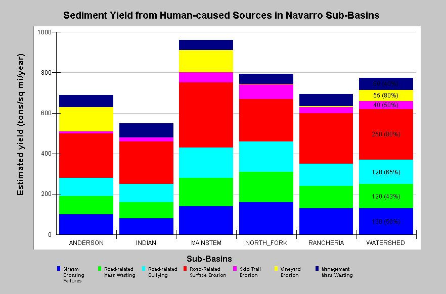 Figure 3. This chart shows estimated amounts of human-caused sediment in the Navarro River sub-basins according to the Navarro River TMDL (U.S> EPA, 2000). Colored bars represent the sediment sources. The major ones are related to roads (blue = crossing failures, light green = road related mass wasting, light blue = gullies forming on roads, red = road surface erosion). The Watershed bar is the watershed-wide total for sediment and the percent in parentheses is the reduction in non-point source sediment recommended by EPA.
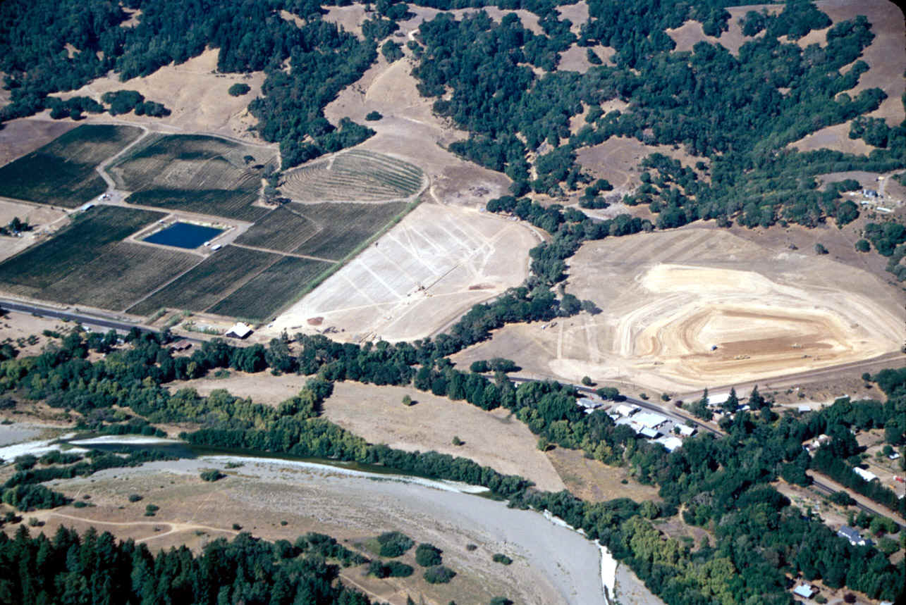 Figure 4. This 2001 aerial photo of the Navarro River shows disturbance related to vineyards development, which U.S. EPA (2000) noted as a potentially significant sediment source. The large excavation at right is a new water storage pond under construction, while the area in the center of the photo is about to be planted in grapes. A small stream winds between the new pond and grape planting and some riparian buffer has been retained. Larger riparian buffer zones can help reduce potential for sediment to enter the streams. Photo by Rixanne Wehren.
The University of California at Davis Information Center for the Environment (ICE) mapped roads in the Navarro River basin for the North Coast Regional Water Quality Control Board and U.S. Environmental Protection Agency as part of the Navarro River TMDL (U.S. EPA, 2000). Figure 5 shows that road densities were well over thresholds recognized as having potential to contribute harmful levels of sediment to streams. (Cedarholm et al., 1981). Road statistics include only main haul roads, not temporary roads, skid trails and landings.
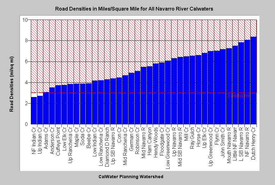 Figure 5. This chart shows the density of roads in miles per square mile for all Calwater Planning Watersheds in the KRIS Navarro project area. The highest road densities, which exceed 8 mi./sq mi., are in areas where industrial timber harvest is the primary land use. Road densities are low in the eastern Navarro watershed where unstable terrain of the Central Belt Franciscan Formation predominates. The three miles per square mile reference is from NMFS (1996). NF Indian Cr = North Fork Indian Creek, Up Indian Cr = Upper Indian Creek, Low Elk Cr = Lower Elk Creek, Mid SB Navarro R = Middle South Branch Navarro River. Data from U.C. Davis ICE.
The Mendocino Redwood Company (MCR) measures permeability of gravels in streams on its property. Figure 6 shows MRC results for 1999 for all locations within the KRIS Navarro project area. Likely survival to emergence of eggs and alevin (Tagart, 1976; McCuddin, 1977) is low in some locations, indicating sediment impairment of spawning gravels.
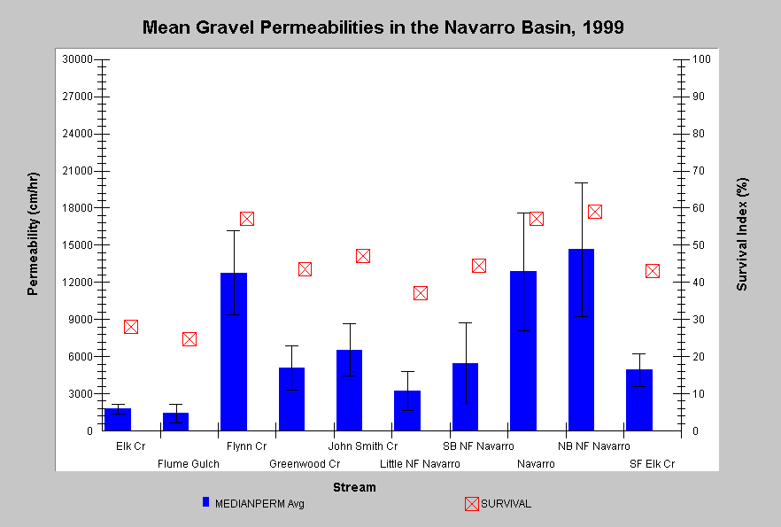 Figure 6. Mean gravel permeability is shown for sampled pool tailouts (pool-riffle transitions) with whiskers representing standard error. Permeabilities are generally low in the Elk Creek, Flume Gulch and the Little NF Navarro River amd salmonid survival is less than 15%. The salmonid egg survival index is plotted on the secondary y-axis and is based on data from Tagart (1976) and McCuddin (1977). Data provided by Mendocino Redwood Company.
Navarro River residents collected turbidity data for the Mendocino Water Agency at two locations. The mainstem Navarro River at the Gowan Ranch was sampled from mid-January to early February 1998 and results indicate impairment with regard to salmonid production.
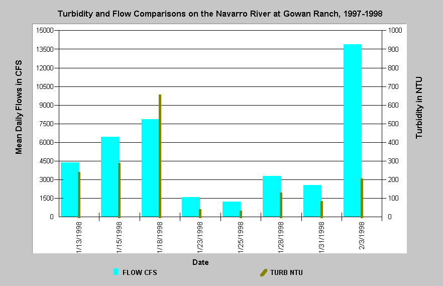 Figure 7. The turbidity measurements of the mainstem Navarro at the Gowan Ranch in January and February 1998 range from 27-650 ntu. While values fell after mid-January storms, they rose again with new rainfall later in the month and early in February. Although there was no continuous recording of turbidity, it appears that levels were greater than those required for steelhead growth (<25 ntu) for the entire duration of this record. The length of time that fish are exposed to elevated turbidity makes a large difference on their growth and survival.
The Mendocino Redwood Company gravel measurements include dry sieve samples from streams within their ownership, which allows calculation of the median particle size (D50) of the stream bed. Measurements in some locations show a D50 less than 37 mm (Figure 8), the reference level recognized by Knopp (1993) as representative of intensive management and high watershed impacts. Small particle size distribution is associated high bed load mobility, which can impair salmonid egg and alevin survival (Nawa et al., 1990).
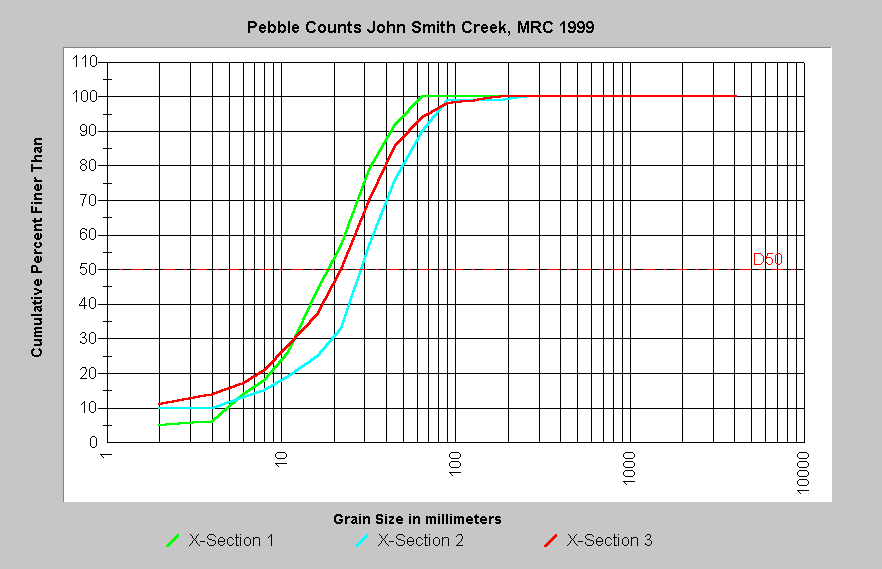 Figure 8. This chart shows the particle size distribution from John Smith Creek with the median particle size (D50) ranging from 18-29 mm at three cross sections. This small D50 indicates potential impairment with regard to salmon and steelhead spawning because of the elevated potential for stream bed movement during storm events. Data from the Mendocino Redwood Company.
California Department of Fish and Game Navarro River habitat typing surveys allow calculation of pool frequency by length (Figure 9) and pool depth (Figure 10). CDFG (1998) noted that pool frequency of greater than 50% was optimal for salmonids but several Navarro tributaries have fewer than 20% pools, indicating sediment impairment. Dry reaches indicate the highest level of sediment impairment where the stream is buried so deeply that it loses summer surface flow. Similarly, pool depth in the Navarro and its tributaries are indicative of sediment impairment with pools often less than three feet deep. This makes them less than optimal for coho salmon (Brown et al., 1994) and yearling and older steelhead (Reeves, 1988) rearing.
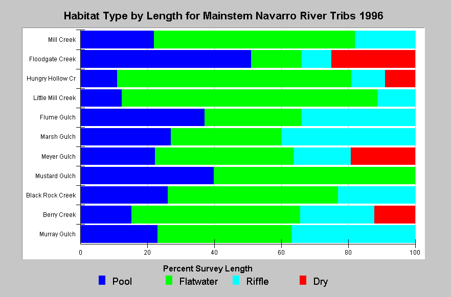 Figure 9. This chart shows the percent of habitats that are pools, riffles and runs (flatwater) by length of streams in the mainstem Navarro River sub-basin according to 1996 habitat typing surveys. Pool habitat by length (blue bars) was under 20% at several locations indicating an impaired condition for salmonid rearing. The Dry percentage habitat shows reaches lacking surface flow, the least productive condition for salmonids. Data from the California Department of Fish and Game. Streams are sorted by Strahler order, with larger streams at the top.
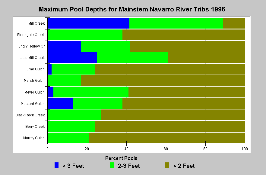 Figure 10. The chart shows maximum pool depths for the mainstem Navarro River sub-basin from 1996 habitat typing surveys. Five of 11 streams surveyed contained no pools greater than 3 feet deep. Three foot deep pools are recognized as necessary for coho salmon (Brown et al., 1994) and older age steelhead juvenile rearing (Reeves, 1988) and lack of pools of this depth is an indicator of sediment impairment. Streams are sorted by Strahler Order, with larger streams at the top. Data provided by CDFG.
Knopp (1993) found that the volume of sediment in pools was related to the intensity of management in a watershed. The Navarro River TMDL recommended that sediment in pools not exceed a V* value of 0.15 for smaller order streams, which is roughly 15% of a pool filled with sediment. Knopp's (1993) results for basins in the KRIS Navarro project area (Figure 11) indicate that pools were roughly 48% and 58% filled with sediment. The compromised pool depths due to pool filling represent impaired conditions for salmonid rearing.
 Figure 11. Knopp's (1993) V* results are shown in this chart for several Mendocino County coastal streams, including the North Branch NF Navarro River and Greenwood Creek, which is also in the KRIS Navarro project area. The NBNF Navarro had a V* of 0.584 while Greenwood Creek pool were nearly half filled with sediment (V* = 0.487). These values are more than triple the Navarro TMDL V* target of 0.15, which U.S. EPA (2000) recommended be applied only to smaller streams in the Navarro basin proper.
Tributaries of the Navarro River like Rancheria Creek (Figure 12) and the North Fork (Figure 12) lose surface flow in summer because their stream beds are buried so deeply in sediment. Loss of surface flow represents the worst possible case of reduced salmonid rearing potential.
 Figure 12. This photo shows the aggraded portion of upper Rancheria Creek in September 2001 lacking surface flow. While water extraction related to agricultural water use may diminish surface flows here somewhat, this reach of stream is highly aggraded, which has contributed to lack of surface flows. The wide, braided channel is characteristic of sediment over-supply. Photo by Patrick Higgins.
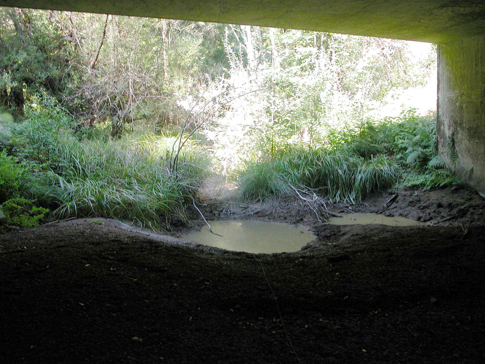 Figure 13. Although Flynn Creek is a coho salmon producer in its headwater reaches, this photo shows lower Flynn Creek at Highway 128 where it is so buried in fine sediment that it has lost surface flow. Material in the streambed is predominately sand. The North Fork Navarro has several tributaries that lose surface flow, yet there is little agricultural water diversion in the sub-basin. Photo by Patrick Higgins. September 21, 2001.
Topics Supporting the Hypotheses
The following is a listing of topics and maps from the KRIS Navarro database that are used above. Viewing them in context allows access to data, Metadata and associated Info Links. The large-case letters in parentheses indicate KRIS Navarro sub-basins.
(BW) Tour: Navarro River Historical Photos, Part 1
(NF) Tour: Historical Photos of Masonite Road Construction #1
(BW) Sediment: Man-made Sources of Sediment by type, TMDL 2000
(MN) Tour: 1. Mainstem Navarro River air photos 2001
(BW) Sediment: Road Densities for All Navarro River Planning Watersheds
(BW) Sediment: Gravel Permeabilities Basinwide, 1999
(MN) Habitat: Habitat Types by Length Mainstem Navarro Subbasin 1996
(MN) Habitat: Maximum Pool Depth Mainstem Navarro Subbasin 1996
References
Barnard, K. and S. McBain. 1994. Standpipe to determine permeability, dissolved oxygen, and vertical particle size distribution in salmonid spawning gravels. As FHR Currents # 15. US Forest Service, Region 5. Eureka, CA. 12 pp. [1.45Mb]**
Brown, L.R., P.B. Moyle, and R.M. Yoshiyama. 1994. Historical Decline and Current Status of Coho Salmon in California. North American Journal of Fisheries Management. 14(2):237-261. (Coho salmon were not found in 21% of their former range in the Navarro River watershed between the early 1980s and 1991, with an estimated population of 300 adults. The authors suggest that a minimum of 100 fish are necessary to preserve genetic integrity.
California Department of Fish and Game (CDFG). 1954. Horse Creek (Rancheria Creek tributary) field note, 13 May 1954 . CDFG unpublished file memo . Yountville, CA . 1 p. [4kb]**
California Department of Fish and Game (CDFG). 1962a. Barton Gulch (Navarro River tributary) stream survey, 27 September 1962 . CDFG unpublished file memo by J. Crowdus . Yountville, CA . 4 pp. [50kb]**
California Department of Fish and Game (CDFG). 1962. Sawyer Creek (Bottom Creek, then Little North Fork Navarro, tributary) stream survey, 16 July 1962 . CDFG unpublished file memo by J. Rowell . Yountville, CA . 3 pp. [133kb]**
Cedarholm, C.J., L.M. Reid and E.O. Salo. 1981. Cumulative effects of logging road sediment on salmonid populations of the Clearwater River, Jefferson County, Washington. Pages 38-74 in Proceedings of Conference on Salmon Spawning Gravel: A Renewable Resource in the Pacific Northwest? Report 19. Wash. State University, Water Research Center, Pullman, WA.
Dietrich et al. 1989. Particle size distribution from KRIS Gualala.
Entrix Inc., Pacific Watershed Associates, Circuit Rider Productions Inc., Navarro Watershed Community Advisory Group, and D.T. Sicular. 1998. Navarro Watershed Restoration Plan. Prepared for Mendocino County Water Agency, California State Coastal Conservancy, and Anderson Valley Land Trust Incorporated. Ukiah. 545 pp. [5Mb]**
Knopp, C. 1993. Testing Indices of Cold Water Fish Habitat. Final Report for Development of Techniques for Measuring Beneficial Use Protection and Inclusion into the North Coast Region's Basin Plan by Amendment of the.....Activities, September 18, 1990. North Coast Regional Water Quality Control Board in cooperation with California Department of Forestry. 57 pp.
McCuddin, M. E. 1977. Survival of salmon and trout embryos and fry in gravel-sand mixtures. Master's thesis. University of Idaho, Moscow.
McHenry, M.L., D.C. Morrill and E. Currence. 1994 . Spawning Gravel Quality, Watershed Characteristics and Early Life History Survival of Coho Salmon and Steelhead in Five North Olympic Peninsula Watersheds. Lower Elwha S'Klallam Tribe, Port Angeles, WA. and Makah Tribe, Neah Bay, WA. Funded by Washington State Dept. of Ecology (205J grant).
McNeil, W. J. and W.H. Ahnell. 1964. Success of Pink Spawning Relative to Size of Spawning Bed Material. U.S. Fish and Wildlife Service, Special Scientific Report - Fisheries No. 469. Washington, D.C. 17 pp.
National Marine Fisheries Service (NMFS) 1996. Coastal Salmon Conservation: Working Guidance for Comprehensive Salmon Restoration Initiatives on the Pacific Coast. September 1996. 5pp. [139kb]
Nawa, R.K., C.A. Frissell and W.J. Liss. 1990. Life history and persistence of anadromous salmonid stocks in relation to stream habitats and watershed classification, annual progress report (4/18/90). Prepared for Oregon Department of Fish and Wildlife, by Oak Creek Laboratory of Biology, Department of Fisheries and Wildlife, Corvallis, OR.
Reeves, G. H., F. H. Everest, and T. E. Nickleson. 1989. Identification of physical habitats limiting the production of coho salmon in Western Oregon and Washington. General technical report PNW-GTR-245. USDA Forest Service, Pacific Northwest Research Station . Portland, OR. 25 pp. [396kb]**
Reeves, G.H.1988. Distribution patterns of fish in the Elk River basin. COPE Report l(3): 4-6.
Reeves, G. H., F. H. Everest, and J. R. Sedell. 1993. Diversity of juvenile anadromous salmonid assemblages in coastal Oregon basins with different levels of timber harvest . Transactions of the American Fisheries Society. 122(3): 309-317. [119kb]**
Sigler, J. W., T. C. Bjornn, and F. H. Everest. 1984. Effects of chronic turbidity on density and growth of steelheads and coho salmon. Transactions of the American Fisheries Society. 113:142-150. [651kb] **
Tagart, J. V. 1976. The survival from egg deposition to emergence of coho salmon in the Clearwater River, Jefferson County, Washington. Master's thesis. University of Washington, Seattle.
U.S. Environmental Protection Agency (USEPA). 2000. Navarro River total maximum daily loads for temperature and sediment. USEPA, Region IX . San Francisco, CA. 45 pp. [1.4Mb]